
- Title: Iowa
- Author: Sidney Edwards Morse
- Date: c.1840
- Medium: Lithograph
- Condition: On thin wavy paper, scattered stains, mild age toning. Edge wear with soiling and evidence of stab binding.
- Inches: 16 x 13 [Paper]
- Centimeters: 40.64 x 33.02 [Paper]
- Product ID: 308076
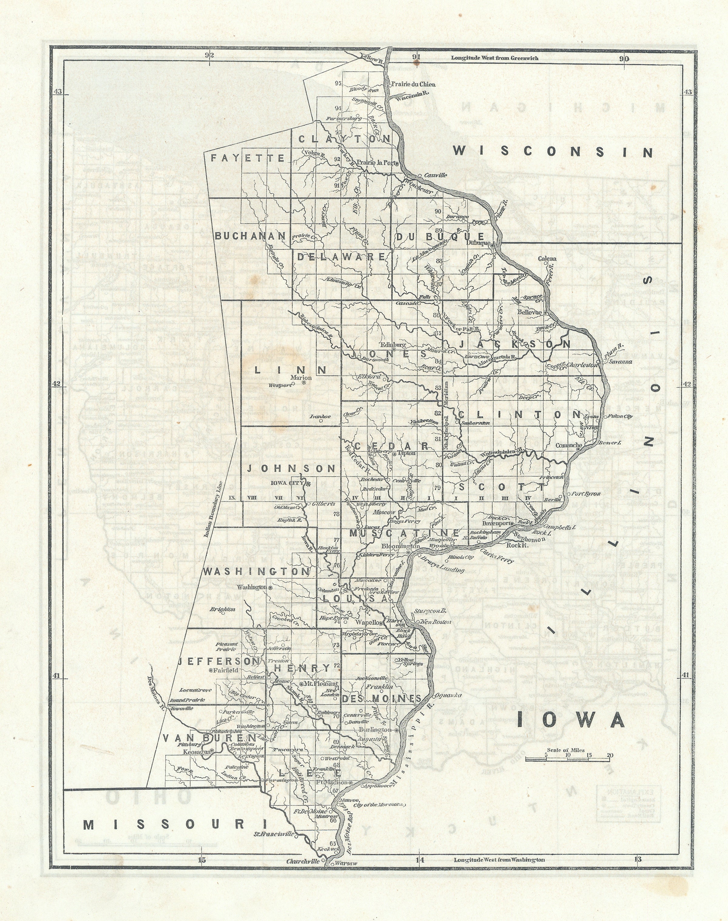
Rare Map of Iowa Territory showing Mormon Settlement of Nauvoo, City of the Mormons
This very early map of Iowa Territory was first issued in the May 29, 1841 edition of the New-York Observer, a weekly religious journal. It depicts the territory with only twenty counties nestled along the Mississippi River and locates a number of towns and settlements, with Iowa City shown as the capital. The map was included to promote Morse's newly developed cerographic process. These "teasers" would later be issued as supplements from 1842-1845 (in three parts), as the Cerographic Atlas of the United States. The present map of Iowa is from the scarce 1842 edition, as all later maps would also include Wisconsin.
The Territory of Iowa was an organized incorporated territory of the United States that existed from July 4, 1838, until December 28, 1846, when the southeastern portion of the territory was admitted to the Union as the state of Iowa.
Nauvoo, City of the Mormons is shown at the bottom center, just east of the Des Moines bend in the Mississippi River. At the time this map was printed historians surmise Nauvoo surpassed Chicago as the largest city in Illinois. Settled by non-native Americans as early as 1824 and undergoing a number of name changes, the name Nauvoo was bestowed by Joseph Smith (Hebrew, "they are beautiful”) in 1840. Joseph Smith was the leader and prophet of the Latter Day Saint movement. Nauvoo grew rapidly and for a few years was one of the most populous cities in Illinois. Within two years of Joseph Smith's killing by a mob in 1844 in Carthage, Illinois, most of the population had departed, fleeing armed violence. The vast majority of Mormons moved west with the group led by Brigham Young.
Sidney Edwards Morse (1794 – 1871) was an American geographer, journalist, and inventor. He shared his innovative spirit with his brother, Samuel F.B. Morse, and his father Jedidiah Morse, who published the first geography book in the United States in 1784. He was born in Charlestown, Massachusetts, graduated from Yale College at fourteen, studied theology at Andover and law at Litchfield, and at sixteen began writing for a Boston newspaper. In 1823 he and his brother Richard established the New York Observer, which was widely hailed the foremost religious paper in the country at the time. Morse took an active interest in science, geography and exploration. He was among the earliest to use the printing process known wax engraving, or cerography, for which he received the U.S. patent.
His best-known works are A New System of Modern Geography (1823), the North American Atlas, the Bible Atlas, and a series of general maps. For several years the sales of the two first- mentioned works averaged 70,000 copies annually, and more than 500,000 copies of his System of Modern Geography were printed.
This map was featured in Morse's North American Atlas, which, when originally published in 1842, was the first atlas of the United States to feature the technique of cerography, or wax engraving.
Verso: OHIO