
- Title: AMERIQUE SEPTENTRIONALIS Divisee en ses Principales Parties PRESENTE' A MONSEIGNEUR LE DUC DE BOURGOGNE
- Author: Alexis-Hubert Jaillot, published by Pierre Mortier
- Date: 1694
- Condition: See description
- Inches: 19 x 23
- Centimeters: 48.26 x 58.42
- Product ID: 308230
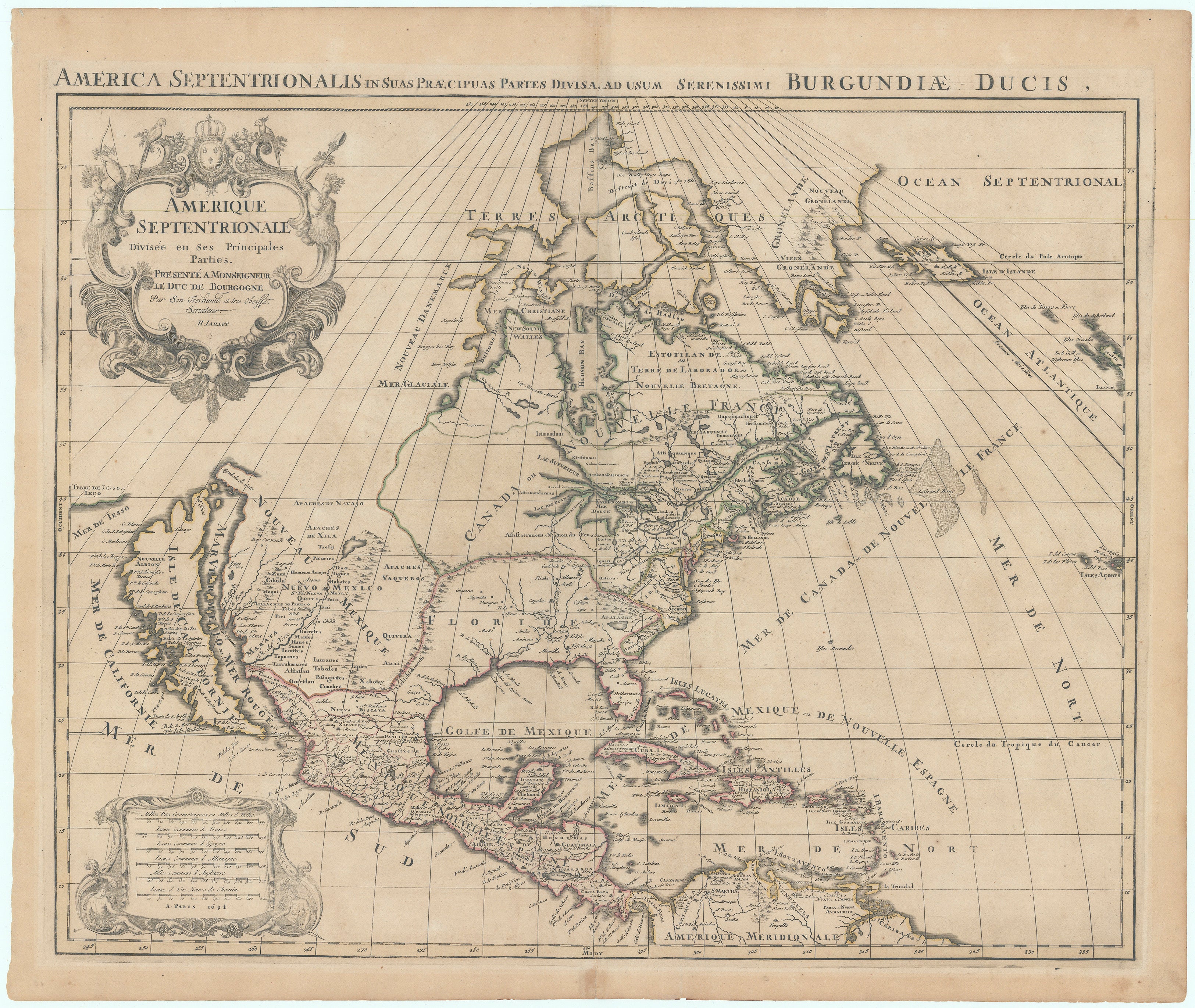
Scarce Map of North America, First State
Two sheet map by Alexis-Hubert Jaillot is from the Atlas Royal, published by Pierre Mortier. This storied image was used with improvements from 1674 to 1792. Borrowing heavily from Guillaume Sanson’s map Amerique Septentrionale of 1669, itself based on Nicolas Sanson’s wall map of 1666. Jaillot included a very similar map in his Atlas Nouveau, dating to 1674 (Burden 438). This is a reduced version of that map. The cartography has not been updated. The Asian coastline present for most of the life of Sanson's earlier 1650 map of North America is here reinserted.
A most interesting deviation occurs with the depiction of the Mississippi, shown with a pronounced eastward slant, perhaps based on information derived from Marquette and Joliet’s expeditions in 1668. The source, however, is pushed far east of its actual headwaters in today’s Minnesota. The western Great Lakes are shown open ended, similarly to the earlier examples, (although curiously enough the open-ended Lakes also show up in some later examples of the map). Lakes Ontario and Superior largely reflect the persistent influence of Sanson’s map of 1656. The east coast of North America is based upon Sanson, although the projection of California is his second projection, differing from Sanson's landmark map of 1656.
Replete with numerous seventeenth century cartographic misconceptions; California as an island, Quivira (the City of Gold) in present day Texas, apocryphal “Terre De Iesso” in the north Pacific, the Rio Grande flowing into the Gulf of California, and much speculative cartography in the interior of North America.
After the Blaeu fire the Dutch supremacy in mapmaking rapidly waned. Paris became the new center of gravity for the map trade. To add cache to the Atlas Royal, the source of this map, Mortier used Paris as the address for publishing, the title page bearing the imprint of Nicolas de Fer, while producing the work in Amsterdam. Creative marketing at its finest!
Background on Cartographer
Alexis-Hubert Jaillot is viewed by some as the successor to Nicolas Sanson, of improving the quality of French mapmaking. He was born in the Franche-Comté around 1632 and became a master engraver in his late teens or early twenties. He travelled with his brother Simon in 1657 to Paris to work as engravers. Alexis-Hubert's future was determined largely by his marriage to Jeanne Berey in 1664. She was the daughter of Nicolas Berey, a merchant of engravings. Alexis-Hubert found himself drawn into the business following the deaths of his father-in-law the following year, and his brother-in-law, Nicolas Il, in 1667. From the latter's widow Alexis-Hubert and his wife acquired the geographical parts of the business.
After establishing a partnership, Jaillot had the elder Sanson's maps redrawn on a larger scale and with fresh embellishments on the finest paper. Jaillot ultimately succeeded Sanson's business and undertook the re-engraving and publishing of Sanson's maps and atlases. Beginning in 1669, he re-engraved and often enlarged many of Sanson's maps, filling in the gap left by the destruction of Blaeu's printing establishment in 1672. In 1681 Jaillot had acquired sufficient stock to publish his Atlas Nouveau. After the relationship with the Sanson brothers eroded (it was rarely smooth), Jaillot turned to Pierre Mortier as his publisher.
Condition
Overall age toning with a few minor spots. Very good.