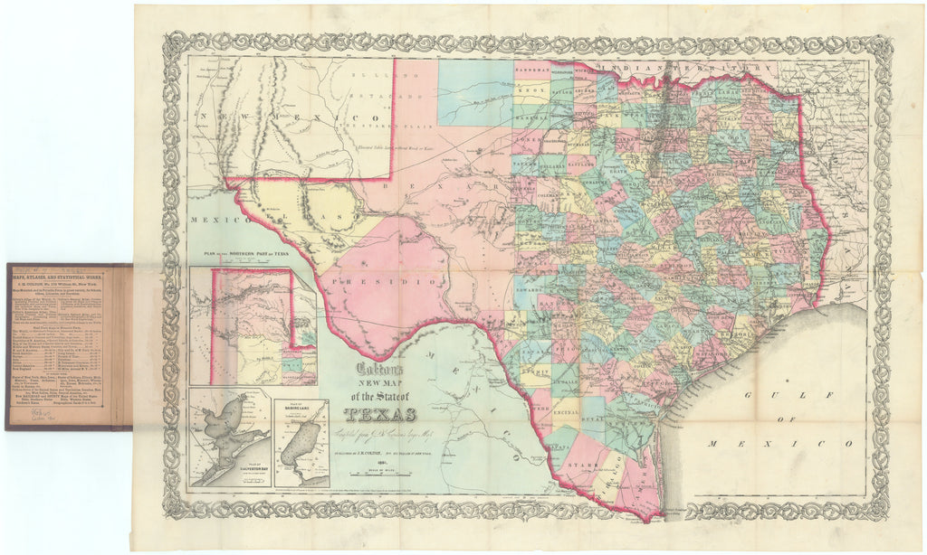
- Title: Colton's New Map of the State of Texas Compiled from J. De Cordova's Large Map
- Author: J. H. Colton
- Date: 1861
- Condition: See description
- Inches: 26.5 x 18.75 [Image]
- Centimeters: 67.31 x 47.63 [Image]
- Product ID: 308252
Unobtainable Issue of Colton Map of Texas
Hand-colored folding pocket map, with ornamental border, outlines in shades of red, with three inset maps at lower left entitled: Plan of the Northern Part of Texas, Plan of Galveston, and Plan of Sabine Lake. Folding into the publisher's 12mo embossed brown cloth covers, gilt-lettered on cover. Housed in a modern quarter morocco slipcase.
This is Jacob de Cordova’s map, completely re-engraved and issued by Colton after he purchased the copyright. Although it shows an outstanding level of detail, showing counties, towns, roads, railroads, rivers, mountains, and German settlements, it is not quite on par with de Cordova’s map. De Cordova's original map was produced in 1849 shortly after the end of the Mexican American War. It became one of the first major maps to be produced after Texas' annexation as a state, known in only a handful of copies, it is the sine qua non of Texas map collections.
Rarity
This issue could prove to be as rare as the original 1849 Jacob de Cordova Map of Texas, known in a handful of copies. Prior to our offering, this issue of the pocket map has appeared in commerce only twice in the last 78 years; 1946 and 2001, RBH, no instances in dealer catalogs during the same period.
The atlas version is known in abundance.
Background on Creators
Jacob de Cordova (1808 – 1868) emigrated to Texas in 1837 and quickly became one of the new Republic’s key promoters. He was responsible for several influential pamphlets and guidebooks, and most famously, the first (1849) edition of his eponymous map. Hoping to cash in on the expected land boom following the Mexican War, de Cordova commissioned Robert Creuzbaur, an employee of the Texas General Land Office, to compile the 1849 edition from the agency’s records. The result was a very detailed and accurate map. De Cordova published the map in Houston about five times between 1849 and 1854, and in 1855 Colton bought the map from Cordova, and republished in New York on another five occasions.
Joseph Hutchins Colton (1800–1893) was a prominent American mapmaker and publisher whose name became synonymous with high-quality maps during the 19th century. Born in Longmeadow, Massachusetts, Colton started his career in the publishing business, eventually turning his attention to cartography. In 1833, he founded J.H. Colton & Company in New York City, a firm that would become one of the most successful and prolific map-publishing houses in the United States. Colton's maps were known for their precision, attention to detail, and decorative elements, making them popular among government officials, academics, travelers, and the general public.
One of Colton's most notable contributions was the publication of the "Colton Atlas," first released in 1855. This atlas featured a comprehensive collection of maps covering the world, individual continents, and various countries. Colton's maps were characterized by vibrant coloring, intricate border designs, and up-to-date geographical information. The success of the "Colton Atlas" solidified Colton's reputation as a leading map publisher in the United States during the 19th century.
Joseph Hutchins Colton's legacy extended beyond his own career, as his sons George Woolworth Colton and Charles B. Colton continued the family's mapmaking tradition after his death in 1893. The Colton firm remained influential in the map-publishing industry well into the 20th century. Today, Colton's maps are prized by collectors for their aesthetic appeal and historical significance, representing a key chapter in the development of American cartography.
Principal Authorities
Philips, A List of Maps of America in the Library of Congress, page 846. Texas State Historical Association On-Line accessed 1-11-2024 (Handbook).
Condition
The map is crisp, brilliantly colored, and very fine except for a few miniscule splits along fold lines (no losses). Covers lightly worn with the upper cover faded.


