
- Title: Mercator and Hondius World and Continents
- Author: Gerard Mercator / Jodocus Hondius
- Date: 1619
- Condition: See description
- Inches: 23 x 18 1/2 [Paper] sheets vary slightly]
- Centimeters: 58.42 x 46.99 [Paper] sheets vary slightly]
- Product ID: 308080
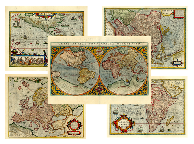
Handsome Matching Set of Mercator/Hondius World & Continents
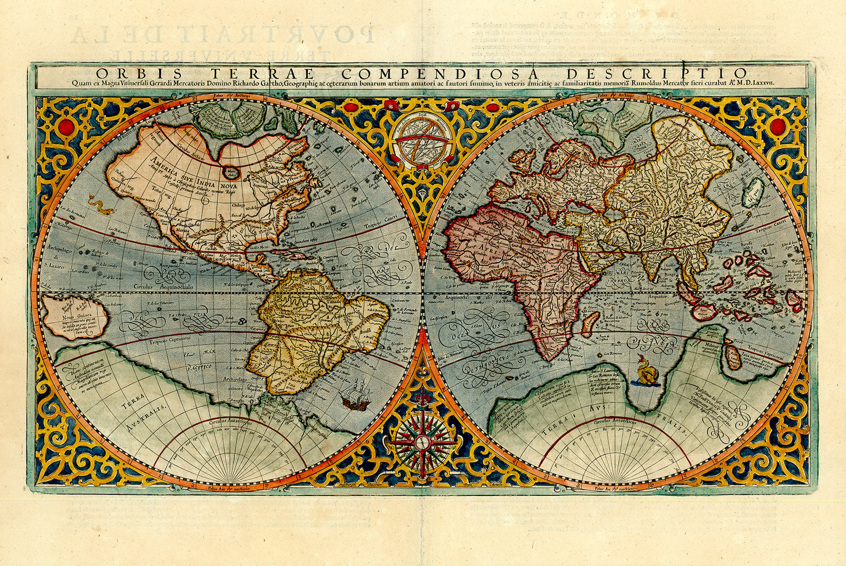
- ORBIS TERRAE COMPENDIOSA DESCRIPTIO quam ex Magna Universali Gerardi Mercatoris Domino Richardo Gartho..., dated 1587 (20.7 x 11.3"). An elaborate strapwork border surrounds this beautiful double-hemisphere map, and an armillary sphere and 32-point compass rose are tucked between the hemispheres. Rumold Mercator based this map on his father's great world map of 1569. The North Pole is depicted as a landmass surrounding a sea from which four rivers radiate and there is a well depicted Northwest Passage. The huge Terra Australis is shown as a part of Tierra del Fuego, and the lands of Lucach, Maletur and Beach (from the travel account of Marco Polo) are noted along the coast in the vicinity of present day Australia with a large island labeled Iava Minor located in the same region. Japan is shown in a kite-shaped configuration, with the fictitious Satyrorum insule (Satyr's Island) shown above. South America has a bulge on its southwest coast, and New Guinea is depicted in a large, circular configuration. The map embodies many ancient authorities and is a wonderful view of classical cartography. Cracks in the copper plate are visible in the title. References: Shirley #157; Suarez (Veil) #31, plt. XI
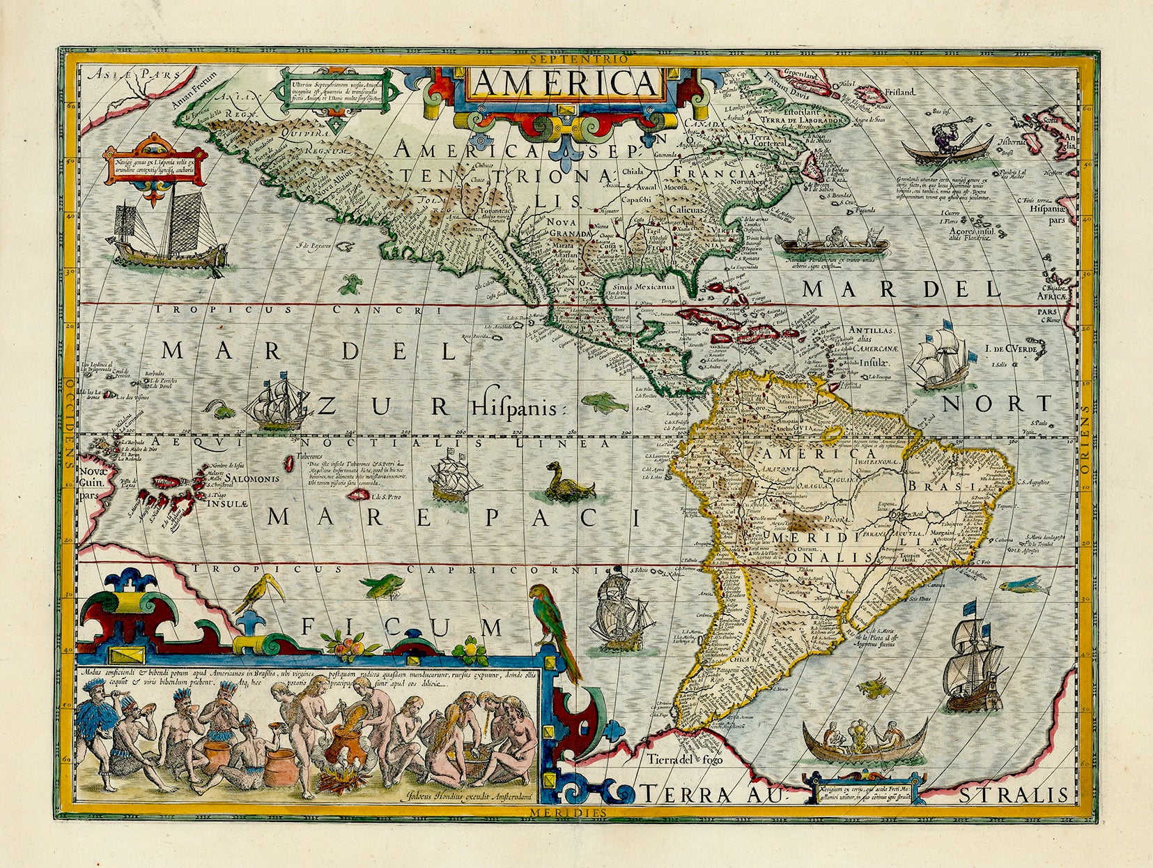
- America (19.9 x 14.8"). Jodocus Hondius' map of the Americas is one of the most elaborate examples of fine Dutch cartography. The decorations, including sea monsters, indigenous birds, native canoes and sailing vessels, are taken from De Bry's Grand Voyages. Particularly notable is the scene of natives preparing an intoxicating drink made from manioc roots, which is derived from Hans Staden's harrowing venture into Brazil. The continents are presented on a stereographic projection, which was becoming increasingly popular at the beginning on the 17th century. It presents a more correct western coastline of South America and narrows the breadth of Mexico. However, North America is still too broad and Virginia has an exaggerated coastline. Newfoundland is based on Plancius. The coastlines are fully engraved with place names. References: Burden #150
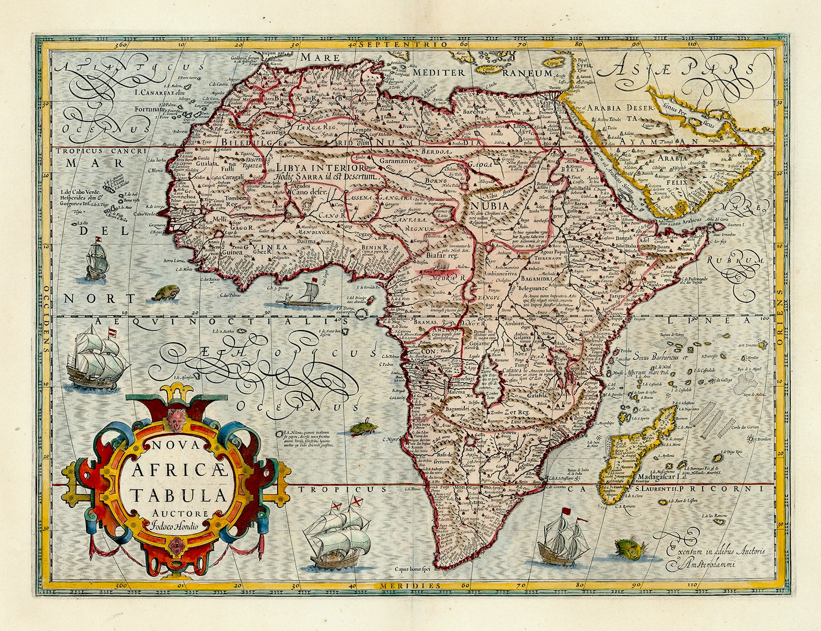
- Nova Africae Tabula (19.9 x 14.8"). In 1606 Jodocus Hondius acquired the copperplates of Mercator's Atlas, to which he added thirty-seven of his own composition, and republished this enormously influential atlas. His map of Africa strongly reflects Mercator's style with the moiré style engraving to denote the oceans and large handsome cartouche of interlocking strap design. It is also geographically based on Mercator with updates from many sources including Pigafetta, Ramusio, De Barros, and Linschoten. The eastern coastline, particularly that of Madagascar, is considerably altered. Hondius improved the southern tip by inserting Saldanha Bay and Cape False and discarding Cayneca. The map is embellished with several sailing ships, sea monsters, and a large strapwork cartouche. References: Norwich #27
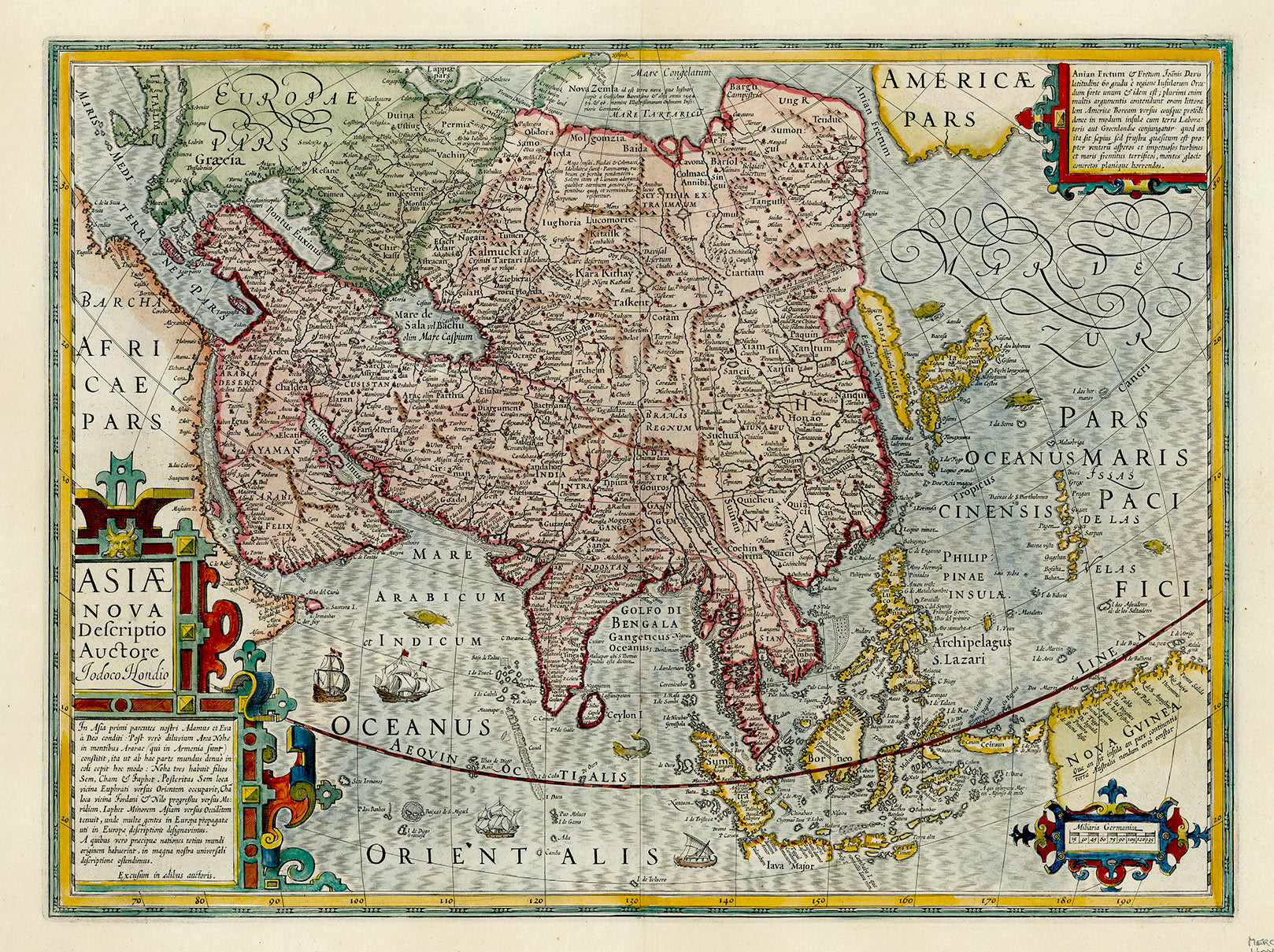
- Asiae Nova Descriptio (19.9 x 14.9"). This excellent map of Asia was Hondius’ update of Mercator’s map of 1595. Though it corrected many of Mercator’s errors, the map still has many interesting early innacuracies. Korea is shown as a very long island. Japan is depicted on the Ortelius-Teixeria model with three principal islands. In India, the Gulf of Cambay is very exaggerated, but the shape of Ceylon has been improved. The mythical Chami Lacus appears to the northeast of India. The Philippines are marked as the Philippina Insulae, as well as Archipelagus S. Lazari, Magellan’s original name for the group. The southern coastline of Java is left blank. The northern coastline of New Guinea includes many place names from Spanish expeditions, and there is a note that it is unknown if New Guinea is a part of Terra Australis. Across the Anian Fretum lies part of North America, labeled Americae Pars, with a cartouche notation concerning the searches for a Northwest Passage. The map is richly decorated with strapwork cartouches, ships, and numerous sea monsters.
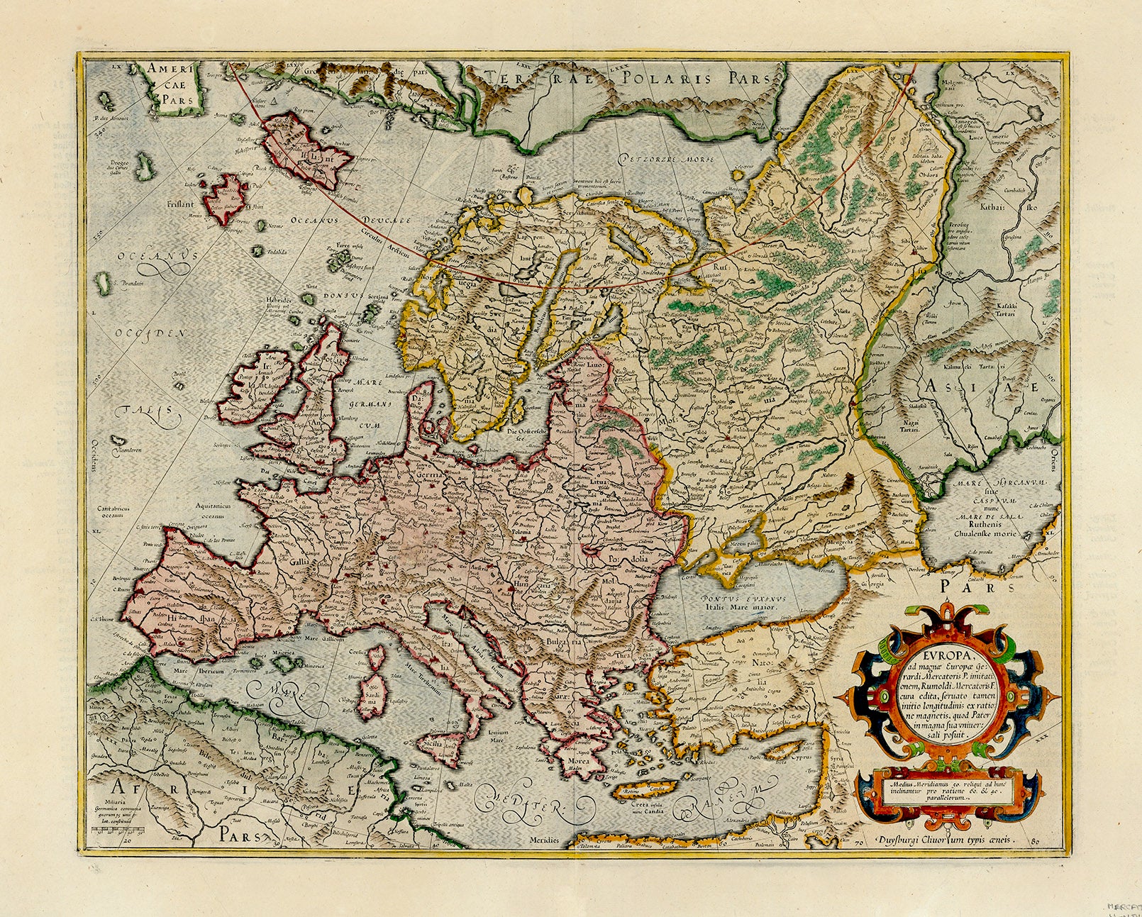
- Europa, ad Magnae Europae Gerardi Mercatoris P. Imitationem... (18.6 x 15.1"). A beautiful map in Mercator's strong engraving style with the seas filled with waves and the land dotted with tiny cities. All of Europe is depicted, as well as Americae Pars, Greenland, Iceland, a Polar landmass, along with the mythical islands of Frisland, Drogeo, and Bradain. A large strapwork title cartouche completes the sheet.
Condition: Dark, crisp and lush impressions on wide-margined, bright sheets, professionally conserved with cleaning and repaired centerfold separations at the bottom of each sheet, entering the image on the maps of the Americas and Europe about 1.5" on each. The map of Europe also has marginal archival repairs to several short tears and one large chip, none entering the image.
Background on Cartographers
The Mercator family of cartographers produced some of the most important maps of the sixteenth century. Gerard Mercator, (1512-1594) was a Flemish mathematician and cartographer. For nearly sixty years, during the most important and exciting period in the history of modern mapmaking, Gerard Mercator was the supreme cartographer, his name, second only to Ptolemy, synonymous with the form of map projection still in use today. He is considered the founder of mathematical geography. He studied at the University of Louvain under the famous astronomer Gemma Frisius. Mercator is famed for the development of the Mercator Projection, first demonstrated on his world map of 1569, which allowed any compass course to appear as a straight line. His next project was the creation of a complete world 'Atlas', the first publication to be called by that name.
Gerard Mercator died on December 2, 1594, leaving the responsibility for completion of his “atlas” to his son Rumold (1545-1599). In 1604, ten years after Mercator’s death, Jodocus Hondius (1563-1612) a publisher in Amsterdam, acquired the Mercator plates. He published several editions, adding new maps to the book, up to 156 in the 1619 edition. After Hondius's death, his widow, Colletta van den Keere, with her seven children continued publishing the atlases under the name of Jodocus Hondius until 1620. The firm was reinforced by the very welcome help of Joannes Jansonius (1588-1664), who married 24-year-old Elizabeth Hondius in 1612. After 1619 the Atlas was published under the name of Henricus Hondius, Jodocus Hondius's son.
Mercator / Hondius Principal Creators:
1595-1599 Rumold Mercator
1604 Jodocus Hondius
1612 Hondius widow, Coletta van den Keere
1619 Henricus Hondius
1624 Joannes Jansson