
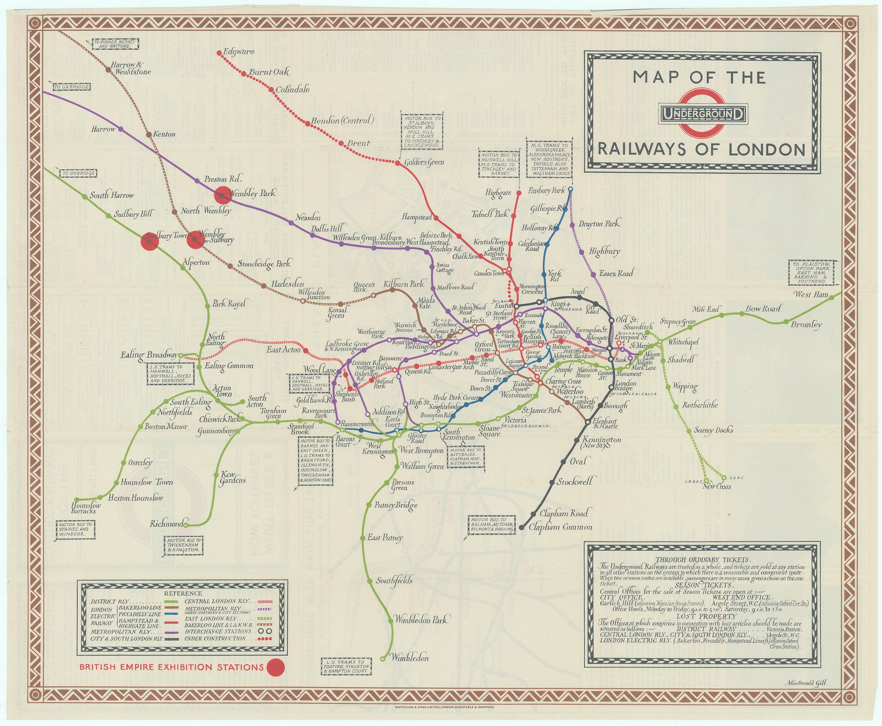
- Title: Map of the Underground Railways of London
- Author: Macdonald Gill
- Date: 1923
- Condition: See description
- Inches: 17 x 14 [Paper]
- Centimeters: 43.18 x 35.56 [Paper]
- Product ID: 308226
Extremely Rare MacDonald Gill London Underground Map
Original color-printed folding map of the London Underground designed by MacDonald Gill. Each Underground line is represented with a different color and includes the names of tube stations, with the British Empire Exhibition Stations (at Wembley) highlighted in red in anticipation of the British Empire Exhibition. More organic than those in Harry Beck's later design for his iconic tube map, this is a lovely and eminently usable map.
The map shows all the Underground Group railways plus the Metropolitan Railway. The map shows all lines in their entirety except the Metropolitan which is shown as far as West Harrow, the Bakerloo and L&NWR line to Harrow & Wealdstone and the District line as far as South Harrow in the West and West Ham in the East, stations beyond the boundaries of the map are indicated in boxes at the end of the lines.
For simplicity there are no geographical features shown on the map. Railways under construction are represented as dotted lines as used on the Hampstead & Highgate line between Charing Cross and Kennington and for the extension to Edgware, on the Piccadilly line between Hammersmith and Ravenscourt Park and for the City & South London Railway extension to Morden. Connections to motor bus and tram services are given in a text box which points to the relevant Underground station. Interchanges are marked by circles and white line interconnectors and station names are all printed in black. Reference key and information on tickets in inset panels at the bottom of the map, brown decorative border featuring the Underground roundel and title in the top right-hand corner.
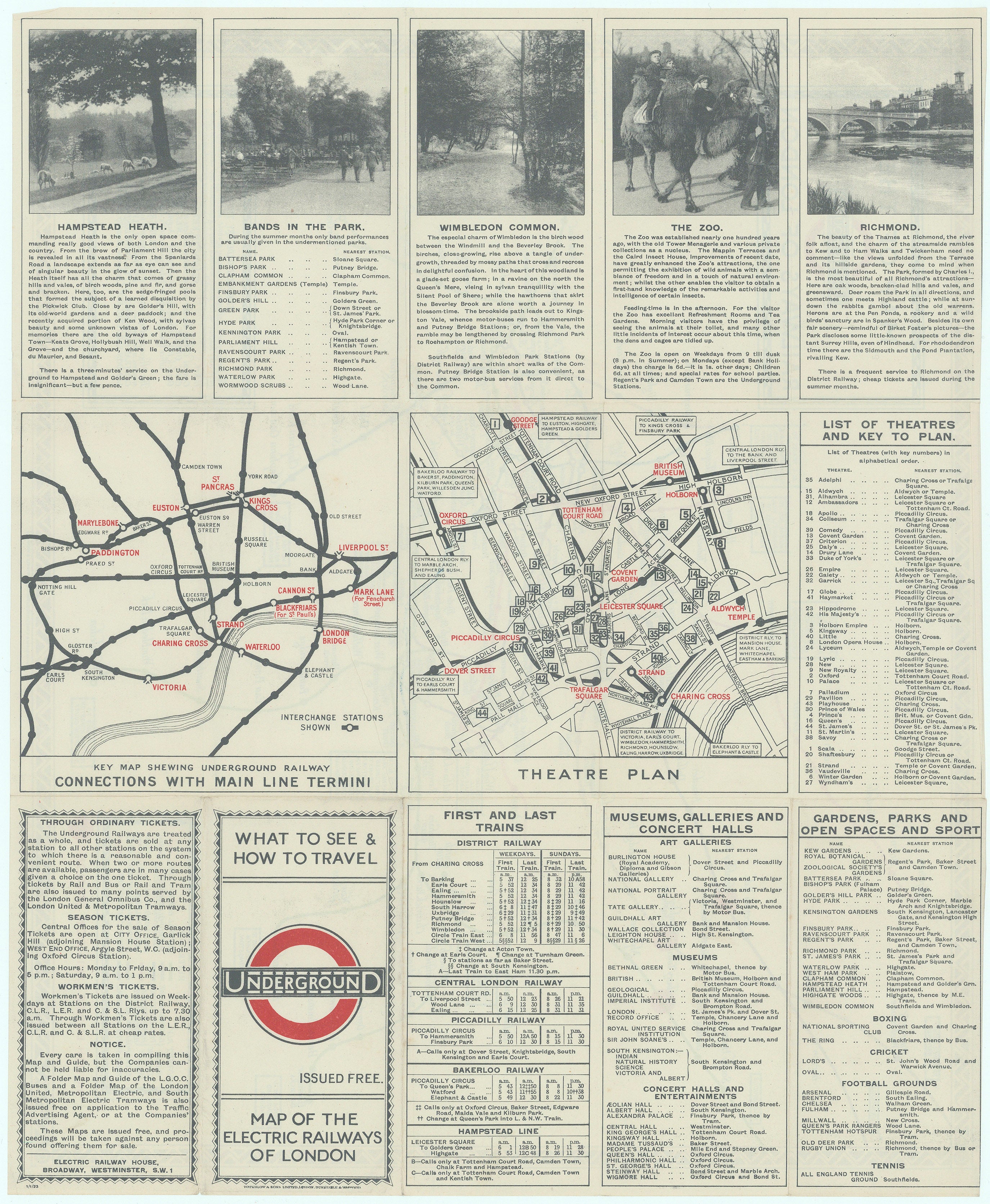
Insets on the covers show diagram with main line connections and a map of theatre land. There are also details about first and last trains, business centers, markets, hotels, restaurants, museums, galleries, concert halls, public buildings, hospitals, gardens, parks, sports grounds, historical buildings, churches and ticketing.
Background on Creator
The revival of the decorative map in the 20th century is often attributed to MacDonald 'Max' Gill. Although his painted maps would decorate the homes of wealthy landowners, prominent public buildings and Cunard liners, it was Gill's poster maps that brought him fame. In the first half of the 20th century, the golden age for poster art, his poster maps spearheaded major publicity campaigns for such institutions as the London Underground and the Empire Marketing Board. The energetic Gill was also an architect, letterer, mural painter and commercial artist (British Library).
References:
London Transport Museum, British Library, both on-line and accessed 10-27-2023.
Condition
Very light even toning and minimal nicks to some folds, upper cover with some light spotting and ink marks. Excellent copy of this scarce Gill map.