
- Title: See Detail in Description [The Only Known Set of Four Continental Wall Maps by Nicolas de Fer. All early states: America (1698), Africa (1698), Asia (1696), and Europe (1695)]
- Author: Nicolas de Fer
- Date: 1695-1698
- Condition: See description
- Inches: Approximately 45 x 65
- Centimeters: Approximately 114.3 x 165.1
- Product ID: 308152
World Heritage designations signify the remarkable accomplishments of humanity and serve as evidence of our intellectual history on the planet. This offering of a truly unique set of late seventeenth century wall maps meet these qualifiers. These maps are more than just remarkable survivors, they are a living testament to the early beginnings of the modern world.
A set of four Enlightenment wall maps; the Americas (1698), Africa (1698), Asia (1696), and Europe (1695), all with title banner dated 1698 with the Royal Privilege, and text panels dated 1703. Each map printed on four joined sheets with a surmounted title above, and engraved text panels at the sides and bottom providing extensive cultural, political, and geographic information. The dramatic cartouches and vignettes depicted in the maps, the work of multiple engravers, are masterpieces of baroque display. They capture the people, wonders, resources, and cultures of faraway lands eagerly sought by Europeans during this dynamic period. The excitement of discovery and understanding of varied cultures is richly conveyed. The maps’ geography, according to the titles, was furnished by members of the French Royal Academy of Sciences.
The Enlightenment – the great ‘Age of Reason’ – is defined as the period of rigorous scientific, political and philosophical discourse that characterized European society during the ‘long’ 18th century: from the late 17th century to the ending of the Napoleonic Wars in 1815. This was a period of huge change in thought and reason, which (in the words of historian Roy Porter) was ‘decisive in the making of modernity’. Centuries of custom and tradition were brushed aside in favor of exploration, individualism, tolerance and scientific endeavor, which, in tandem with developments in industry and politics, witnessed the birth of the ‘modern world’.
Mapmaking was emerging from an equal focus on the decorative and descriptive to a more analytic sensibility at this stage in history. Nicolas de Fer successfully navigated this era with these monumental wall maps, created with the patronage of the Dauphin of France. A very limited quantity of large wall maps were produced by the major cartographic houses for the nobility and wealthy merchants to satisfy curiosity about the world beyond Europe. Grand wall maps such as these were mounted on canvas and exposed to not only environmental factors, but also failing fortunes, wars, political intrigue, economic turmoil, and, sadly, neglect. Thus, the great majority of wall maps produced during this period have been obliterated from the human record, never to reappear, and the incidence of this type of map passing down to our era is astonishingly small.
Provenance
That not only one individual wall map, but the only known set of all four have been spared is down to being displayed in a villa near Milan owned by an aristocratic Italian family of the middle nobility, possibly since they were created in the Parisian workshops of Nicolas de Fer, prior to our acquisition.
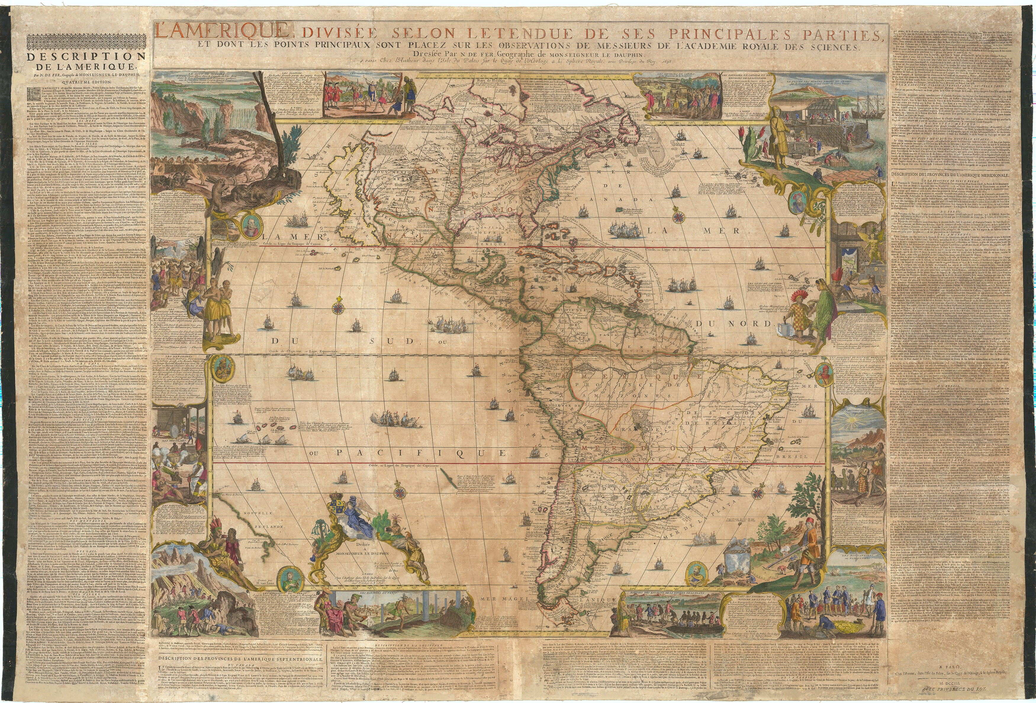
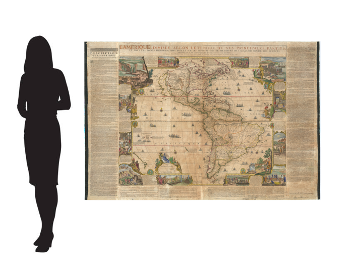
The Map of The Americas
L'AMERIQUE DIVISÉE SELON L’ETENDUE DE SES PRINCIPALES PARTIES, ET DONT LES POINTS PRINCIPAUX SONT PLACEZ SUR LES OBSERVATION DES MONSIEURS DE L’ACADEMIE ROYALE DES SCIENCES. Dressée par N DE FER, Geographe de MONSIEUR DE DAUPHIN. A PARIS Chez l’auteur dans l’Isle du Palais, sur le Quay de l’Horloge, à la Sphere Royal. Avec le Privilege du Roy, 1698
[AMERICA DIVIDED ACCORDING TO THE EXTENSION OF ITS PRINCIPAL PARTS, AND WHOSE PRINCIPAL POINTS ARE PLACED ON THE OBSERVATIONS OF THE GENTLEMEN OF THE ROYAL ACADEMY OF SCIENCES. Drawn up by N DE FER, Geographer of MONSIEUR DE DAUPHIN. IN PARIS At the author’s on the Isle du Palais, on the Quay de l’Horloge, at the Sphere Royal. With the Privilege of the King, 1698]
Second printing of 1698 first state, with the dedication to the Dauphin, Louis XIV’s son within an ornamental cartouche. In the first printing the lower left sheet bears the imprint only.
The classic wall map of North America, famous for introducing to the world an accurate depiction of the interior, and the fantastic Beaver Scene. As Suarez states, French map making of North America really began to mature with the publication of Nicolas Sanson’s atlas in 1650. Usually lacking the fine Dutch artistry of the time, the French succeeded in their greater accuracy, deriving from their strategic control and understanding of the vital lakes and waterways draining the fertile lands in the heart of North America. As a result of their unrivalled knowledge and precision, French maps would become the most valuable and influential in colonial North America. Indeed, this control would be greatly envied and ultimately challenged by the English, whose coastal enclaves, while valuable, lacked the territorial grasp they desired.
J.B. Franquelin, who was stationed in Montreal, combed the records of such storied explorers as Champlain, Nicollet, Hennepin, La Salle, Jolliet, and Marquette as well as Jesuit missionaries and trappers, along with the legends and knowledge of the indigenous peoples to produce manuscript maps of the interior. With privileged access to these sources, de Fer synthesized what was essentially state of the art data to create a map representing the apex of European knowledge of North America at the end of the seventeenth century. He properly aligned Hudson’s Bay above the Great Lakes, which are portrayed with exceptional accuracy exceeding all earlier efforts. The southern reaches to the Great Lakes are better aligned with the east coast. The map shows advanced knowledge of the Mississippi River drainage, although still emptying in the Gulf of Mexico in Texas, much too far to the west, following the school of Coronelli. Arguably the first accurately defined Missouri River, named “Outantes R”., is found, although the Ohio River is placed far to the south.
‘What is so remarkable about de Fer’s map is that it records how within a mere few decades France’s explorers, traders, and missionaries had dragged Europe’s knowledge of the North American interior – about a third of the continent – from that of ignorance to sophistication’
‘This separately produced work was re-issued, apparently in greater numbers, in 1705. The present example is possibly the only survivor of the original 1698 issue with the full text panels intact’. (Suarez).
Burden also spent a considerable amount of time studying this map, and had much to say. Some of the more general outlines bear a similarity to Vincenzo Maria Coronelli’s two sheet map “AMERICA SETTENTRIONALE” published in 1688, whose sources were also French. California is still depicted as an island, on the verge of it being restored as a peninsula by mainstream cartographers.
With one of the most celebrated vignettes in all of cartographic history, the beaver scene. De Fer incorporates the first published view of Niagara Falls, from Guerard’s “Nouvelle Decouverte”, 1697, and famously embellishes the scene with native beavers building a dam. As Ed Dahl points out in his study of the scene, it is wildly inaccurate, but quite entertaining. The beavers are shown in regimented order, carrying branches over their shoulders; walking on their hind legs carrying mud in their tails, while a key nearby identifies ‘woodsmen’, ‘carpenters’, ‘porters’ and even a ‘commander or architect’. The presence of the beaver symbolized the nature of what it was that drove European, and especially French explorers: a plentiful supply of them. The pelt of the beaver was highly prized by fashionable Europeans.
The top right of the map bears a scene illustrating the typical cod-finishing factory found along the Newfoundland coast. The fisheries of the Grand Banks were the other economic mainstay of the region.
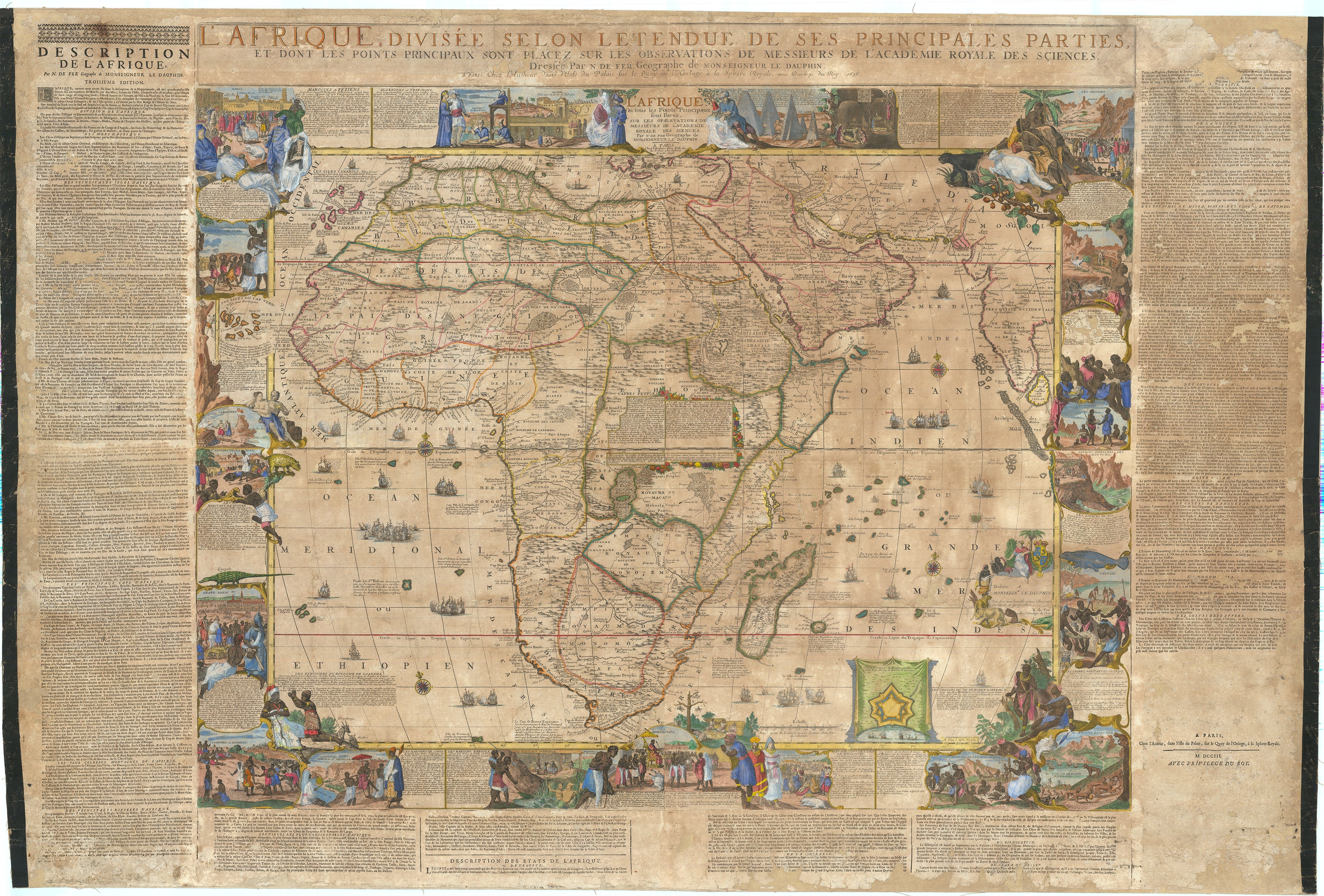
The Map of Africa
L'AFRIQUE DIVISÉE SELON L’ETENDUE DE SES PRINCIPALES PARTIES, ET DONT LES POINTS PRINCIPAUX SONT PLACEZ SUR LES OBSERVATION DES MONSIEURS DE L’ACADEMIE ROYALE DES SCIENCES. Dressée par N DE FER, Geographe de MONSIEUR DE DAUPHIN. A PARIS Chez l’auteur dans l’Isle du Palais, sur le Quay de l’Horloge, à la Sphere Royal. Avec le Privilege du Roy, 1698
Africa on a fantastic scale with extensive notations, cartouches, and foliate paneled legends throughout. Dedicatory cartouche with Arms of the Dauphin of France, depicting the fleur-de-lis and the dolphin, in the southern Indian Ocean. The side panels with extensive text entries for the division of the continent, coastal cities, principal islands, capes, rivers, mountains, countries, cities, and one lengthy description of the source of the Nile. Richly decorated with more than twenty elaborate scenes showing art, industry, clothing, customs, farming, hunting, trade, battle, landscapes, and hunting. Numerous animals including ostrich, monkey, crocodile, lion, elephant, camel. Plan of the Dutch fort at Cap bonne de Esperance in a draped paneled inset.
With the Arabian Peninsula shown in its entirety. The present rendering of Arabia, based in part on the work of de L’Isle, shows an early conception of the Middle East. In particular, it omits the Sinai Peninsula included in several of de Fer's earlier efforts. Among the toponyms along the coast of the Arabian Gulf are Abadan, Sur, Ahsa, Janama, Bahr, El Catif, Bischa, Borou, Godo, Vodana, Calba, Dadana, and Pinder.
Although the coastlines of Africa are well mapped, the lack of understanding of the interior is profound. De Fer, like most of his Dutch and French antecedents and contemporaries, gropes with ineffectual understanding at the African interior, with many of the usual imaginary cities, and numerous gold mines. The Niger river delta is shown divulging on the west coast at 15 degrees north, instead of the Gulf of Benin. The great extent of the Congo river’s (Zaire R.) massive drainage basin is here only hinted at, although its delta is shown within a few degrees of actual at 4 south. The Zembeze (Zambezi) river is also depicted with an attenuated upper reach, but near its actual delta at 18 degrees south. The Nile is finally freed from the twin Ptolemaic lakes and begins to take on its more accurate course.
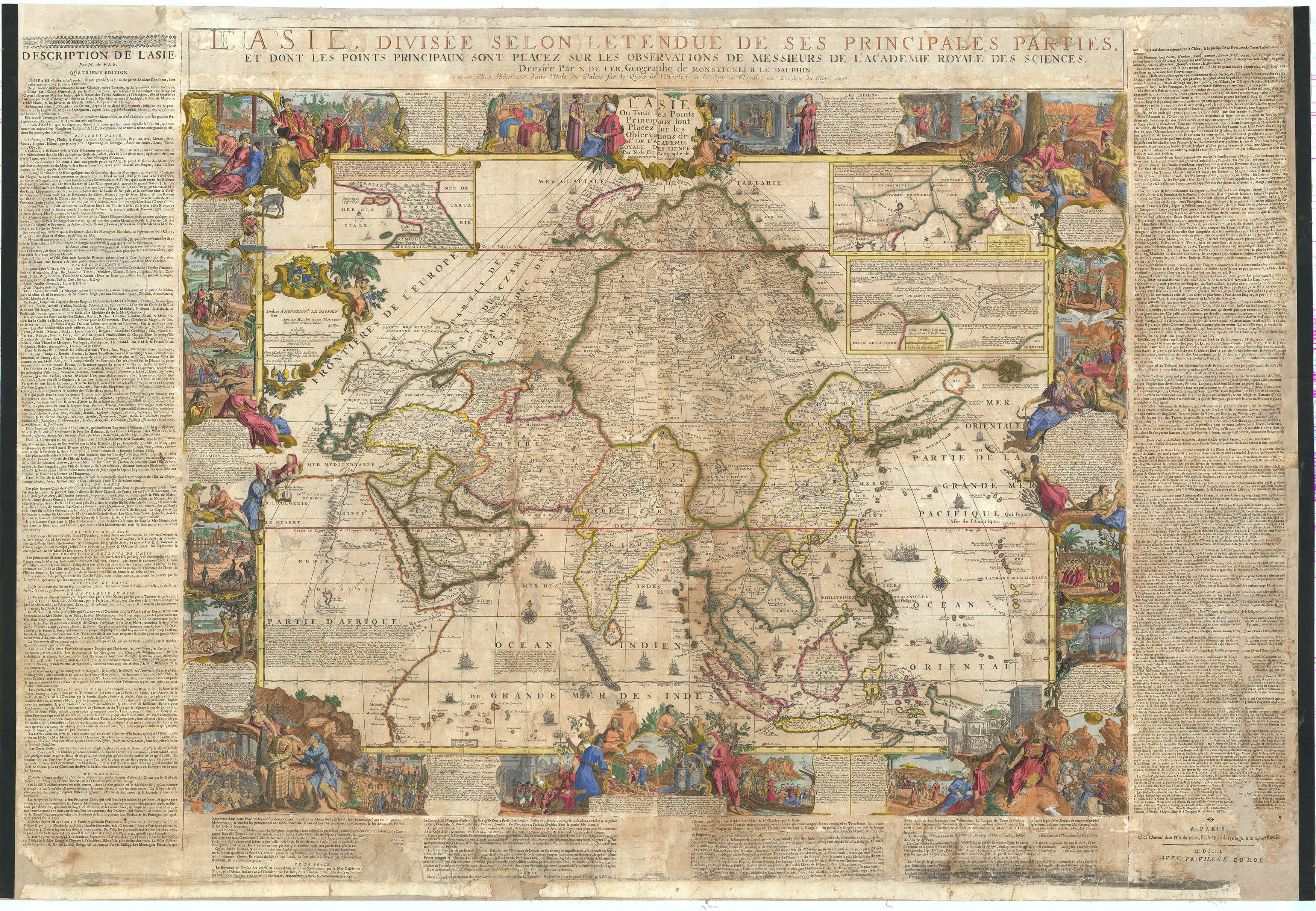
The Map of Asia
L’ASIE DIVISÉE SELON L’ETENDUE DE SES PRINCIPALES PARTIES, ET DONT LES POINTS PRINCIPAUX SONT PLACEZ SUR LES OBSERVATION DES MONSIEURS DE L’ACADEMIE ROYALE DES SCIENCES. Dressée par N DE FER, Geographe de MONSIEUR DE DAUPHIN. A PARIS Chez l’auteur dans l’Isle du Palais, sur le Quay de l’Horloge, à la Sphere Royal. Avec le Privilege du Roy, 1698
This wall map of Asia, dated 1696 within the map, in the dedication to the Dauphin, is the earliest known state. Engraved by Hendrik van Loon after design by Nicolas de Fer. Encompassing the most decorative elements of French map making, this wall map of Asia is particularly striking. It is dedicated to the Dauphin and includes the rare letterpress historical text panels bearing the date 1703. Much of Asia well-charted, based largely on Dutch, for the Philippines, Malaysia, Southeast Asia, and Jesuit sources for areas such as China. The coastlines north of Korea, which is correctly shown here to be a peninsula curving west and northward, beginning and ending in ambiguity.
Inset map of Arctic Asia, with Spitsbergen, and Nova Zembla. Two inset maps of Northeast China based on the writings of the Jesuits Martino Martini and Ferdinand Verbiest. With richly decorated borders, depicting the people, art, religion, commerce, and cultures of Asia. Vignettes showing the Chinese, Japanese, Turks, Indians, Tartars (Russians), Philippines, inhabitants of the Molucca and Sunda islands, Ceylonese, Arabs, peoples from Goa and Mongolia, Armenians, Georgians, people from Golconda, Malaysia, Siam, Cochin and Tonkin. Among the images are those of the faithful during the Hajj visiting the Ka’ba at Mecca.
The borders are set within the rare letterpress panels with extensive text references to Asia, and its geography; rivers, towns, capes, lakes and straights, and including more detailed descriptions of Turkey, Arabia, China, Persia, India, Russia, and Arabic islands in the Indian Ocean.
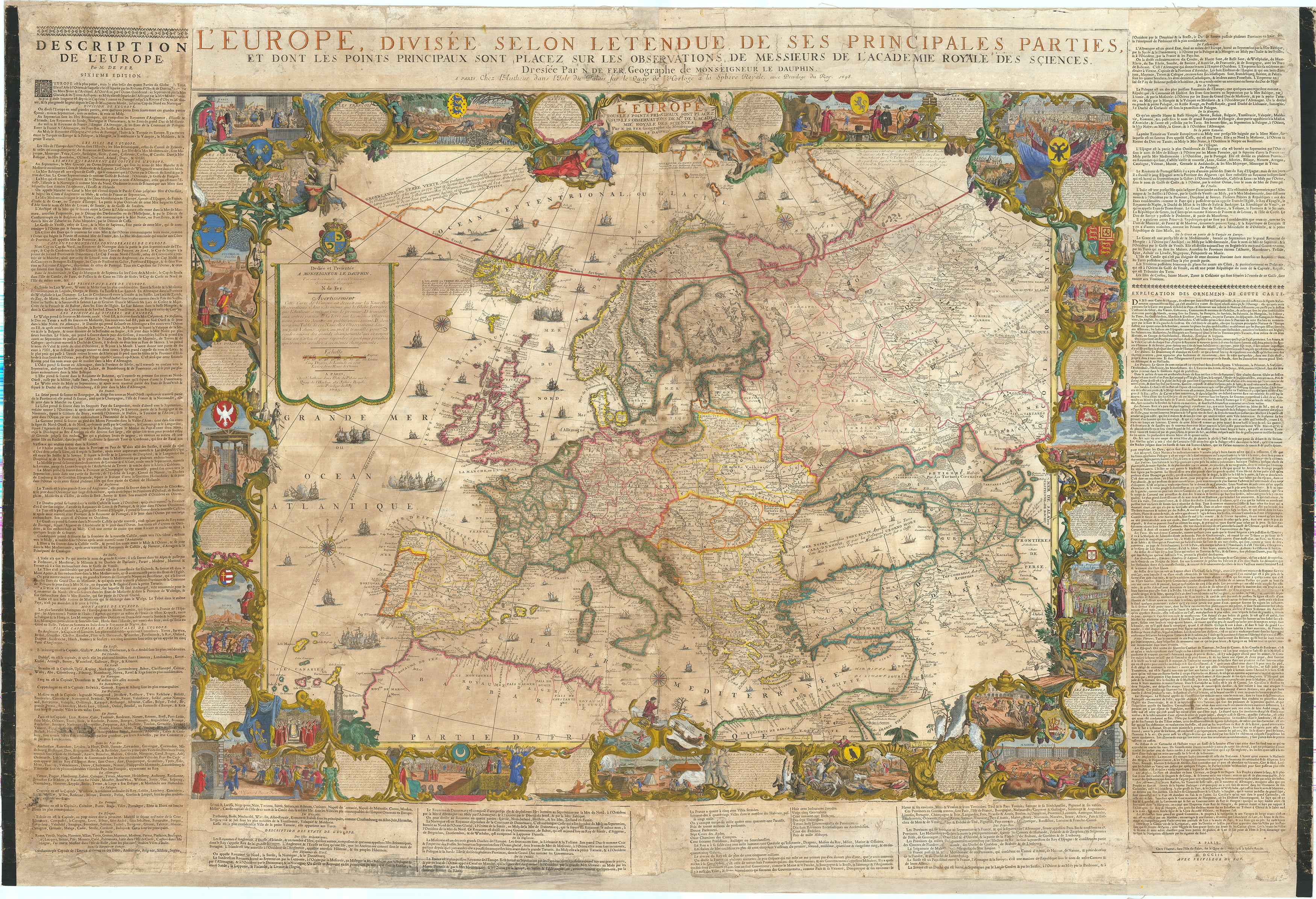
The Map of Europe
L’EUROPE DIVISÉE SELON L’ETENDUE DE SES PRINCIPALES PARTIES, ET DONT LES POINTS PRINCIPAUX SONT PLACEZ SUR LES OBSERVATION DES MONSIEURS DE L’ACADEMIE ROYALE DES SCIENCES. Dressée par N DE FER, Geographe de MONSIEUR DE DAUPHIN. A PARIS Chez l’auteur dans l’Isle du Palais, sur le Quay de l’Horloge, à la Sphere Royal. Avec le Privilege du Roy, 1698
This wall map of Europe, dated 1695 within the map, in the dedication to the Dauphin, is thus the earliest known state.
With sixteen legends in elaborate Baroque vignettes describing principal peoples of Europe; French, Polish, German, Austrian, English, and others, the vignettes interspersed with views of cities, hunting, coats of arms, pageantry, and other fascinating glimpses of a dynamic continent with culture flowering everywhere. The side panels with extensive text entries for the division of the continent, countries, principalities, nobility, cities, principal islands, capes, rivers, mountains, countries, cities, etc.
Background on Cartographer
Widely acknowledged as one of the foremost French cartographers of the late-17th century, Nicolas de Fer is most noted for introducing to the world of cartography its beaver scene. He began his apprenticeship at the age of twelve in the map making business of his father, Antoine de Fer (act. 1644-1672). After his father’s death his mother continued the business and after her retirement, Nicolas took over in 1687. He turned it into a flourishing business and thanks to his contacts with the Académie Royale des Sciences in Paris he was able to use the latest discoveries in geography and subscribe his maps with ‘Dressée sur les nouvelle observations des Messieurs de l’Académie Royale des Sciences.’ In his early career, de Fer is better known for producing small atlases on Europe and France but in 1690 he became the official geographer to the Dauphin, later geographer to the French and Spanish kings. In the 1690s under the Dauphin's patronage he issued a series of wall maps for the wealthy and noble of Europe.
He published more than six hundred maps and many atlases, documenting French fortified towns, strongholds and the explorations and discoveries of new territories. Unlike most Dutch cartographers who mainly made maps for navigational purposes, Nicolas de Fer, in the French decorative style of cartography, made a total of 26 large wall maps to adorn the walls in the palaces and castles of European wealthy merchants, royals, and clergy. His first wall map, in 1694, was naturally of the world, and this was followed by a set of four continents [as here].
Condition
Copperplate engravings, tissue backed for stability, laid to modern cartographic linen. Absolutely untouched with facsimile, some reinstatement of paper in text panels and much less so to very minor loss in maps, old outline color retouched, cartouches and vignettes with recent color. Stabilized cracks, occasional scuffing, overall age toning. All work completed by The Green Dragon.
A superb set, previously unobtainable, by one of the foremost French cartographers of the late-17th century, encompassing the most decorative elements of French map making.
Rarity
No other set of the de Fer Wall Maps of the continents in their earliest incarnation, with or without the side panels, other than the present example, are known to have survived. Examples of individual continental maps in the earliest states, as here, rarely appear on the market. Later states of the map often appear without the surmounted title and text panels. Not on RBH, not on OCLC.
References
Thomas Suarez, Shedding the Veil, no. 48. Philip Burden, The Mapping of North America, II, no. 744. Edward Dahl, The Original Beaver Map – De Fer’s 1698 Wall Map of America, The Map Collector, Issue 29, Dec. 1984, p. 22-26.