
- Title: A New and Exact Map of Spain & Portugal
- Author: Herman Moll
- Date: 1711
- Medium: Hand-colored copperplate engraving
- Condition: Very Good Plus - light age toning, light wear and discoloration along issued quatrefolds, surface dirt, minor creasing throughout, original color (refreshed)
- Inches: 39 ⅜ x 25 [Paper]
- Centimeters: 01 x 63.5 [Paper]
- Product ID: 317017
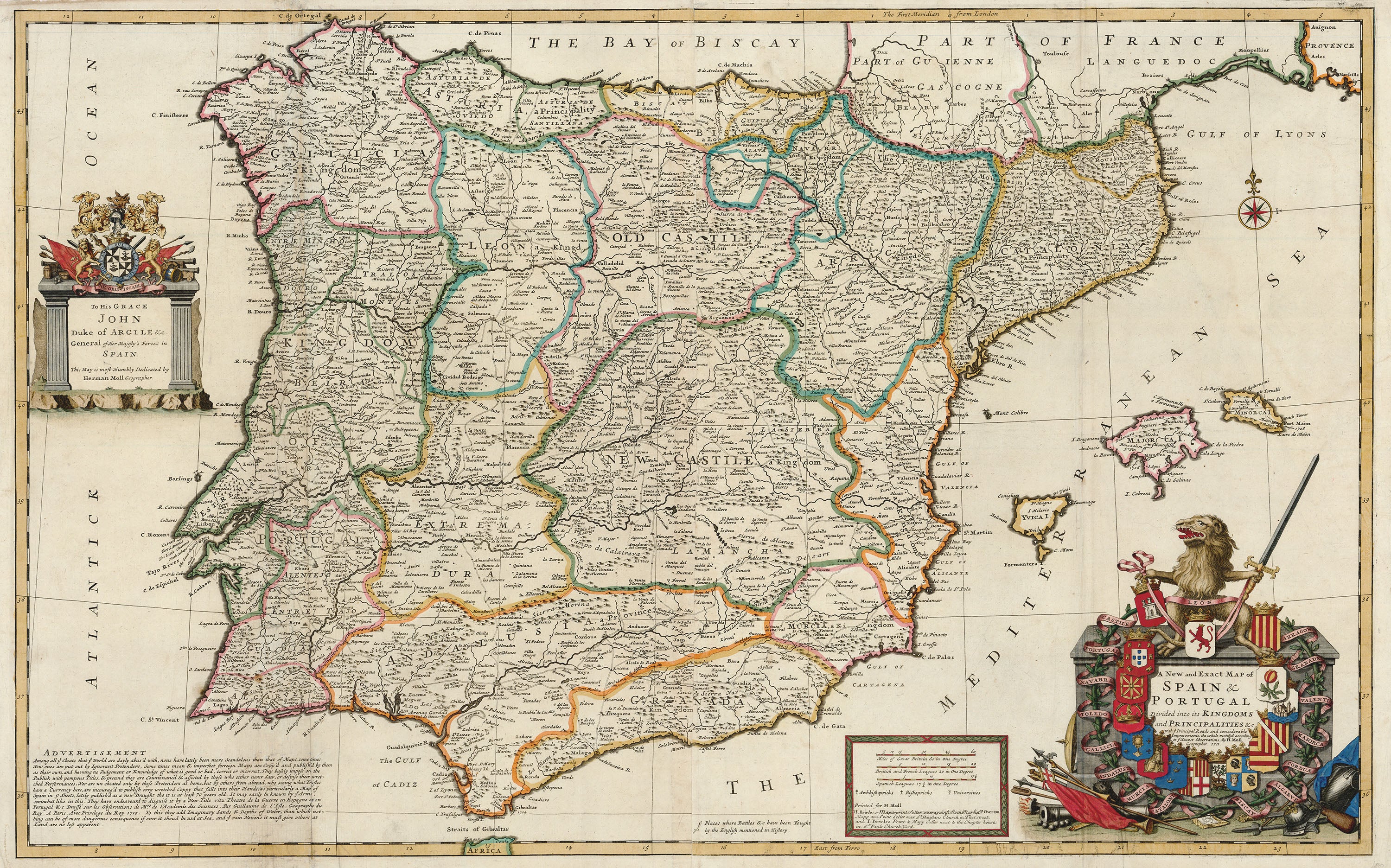
Beautiful large scale map of Spain and Portugal published by Herman Moll in 1711. Moll (c. 1654-1732) made his career in London as a cartographer, publisher, and eventually a producer of pocket globes. However, his birthplace and exact nationality remain unknown. Many assume he could be Dutch due to his involvement in Dutch cartography, the prevalence of the surname ‘Moll’ in the Low Countries at the time, and a trip he took later in life to the region. However, ‘Moll’ was also a German name, casting this hypothesis into doubt. Moll enjoyed a long and successful career, collaborating frequently with other London publishers and engravers and earning an esteemed reputation among his intellectual contemporaries. In fact, he is mentioned by name in Jonathan Swift’s famous novel Gulliver’s Travels (1726). His maps, noted for their ornament and beauty, retained their influence long after his death, and today remain highly collectible.
Map depicts the Iberian Peninsula and includes the Balearic Islands of Mallorca, Menora, and Ibiza, the Atlantic Ocean, the Gulf of Cadiz, the Bay of Biscay, the Straits of Gibraltar, the Mediterranean Sea, and the Gulf of Lyons. Elaborate title cartouche shows a sword-bearing lion, representing the province of Leon. To either side extend a ringed vine and ribbon with the names and crests of the other Spanish and Portuguese provinces: Aragon, Granada, Valentia, Majorca, Cordua, Algarve, Biscay, Catalonia, Murcia, Andalusia, Galicia, Toledo, Navarra, Portugal, and Castille. Moll indicates major cities, roads, bishoprics, archbishoprics, universities, and “Places where Battles &c. Have been Fought by the English mentioned in History.” Longitude from the Ferro and London Meridians.
This piece demonstrates the ferocity of cartographic rivalries at the time and the frequency with which mapmakers ‘borrowed’ from one another. Moll includes a choice message aimed at one of his contemporaries, French cartographer Guillaume de L’Isle:
Advertisement:
Among all ye Cheats that ye World are dayly abus'd with, non have lately been more Scandalous than that of Maps, some times New ones are put out by Ignorant Pretenders, Some times mean & imperfect foreign Maps are Copy'd and publish'd by them as their own, and haveing no Judgement or Knowledge of what is good or bad, correct or incorrect, They basely impose on the Publick with pompous Titles, & pretend they are Countenanc'd & assisted by those who either never Saw, or despise their wretched Performances. Nor are we cheated only by these Pretenders at home, but by others from abroad, who seeing what Trifles have a Currency here, are incourag'd to publish evry wretched Coppy that falls into their Hands, as particularly a Map of Spain in 9 Sheets, lately publish'd as a new Draught tho it is at least 70 years old. It may easily be known by ye Arms, somewhat like in this. They have endeavourd to disguise it by a New Title vitz: Theatre de la Guerre en Espagne et en Portugal &c. Dressé sur les Observations de Mrs. de l'Academie des Sciences. Par Guillaume de l'Isle, Geographe du Roy. A Paris. Avec Privilege du Roy 1710. To this they add Imaginary Sands & Depths of Water, than which nothing can be of more dangerous consequence if ever it shoud be usd at Sea, and ye vain Notions it must give others at Land are no less apparent.
To His Grace John Duke of Argile &c. General of Her Majesty's Forces in Spain. This Map is most Humbly Dedicated by Herman Moll Geographer.
Printed for H. Moll
I. Bowles - Map & printseller over against Stock Market P. Overton Mapp and Print Seller near St. Dunstans Church in Fleet street, and T. Bowles Print & Mapp Seller next to the Chapter house in St. Pauls Church Yard.