
- Title: Map of the State of Texas
- Author: Jacob De Cordova
- Date: 1866
- Condition: See bottom of description
- Inches: 31.5 w x 35 h [Image]
- Centimeters: 80.01 w x 88.9 h [Image]
- Product ID: 308091
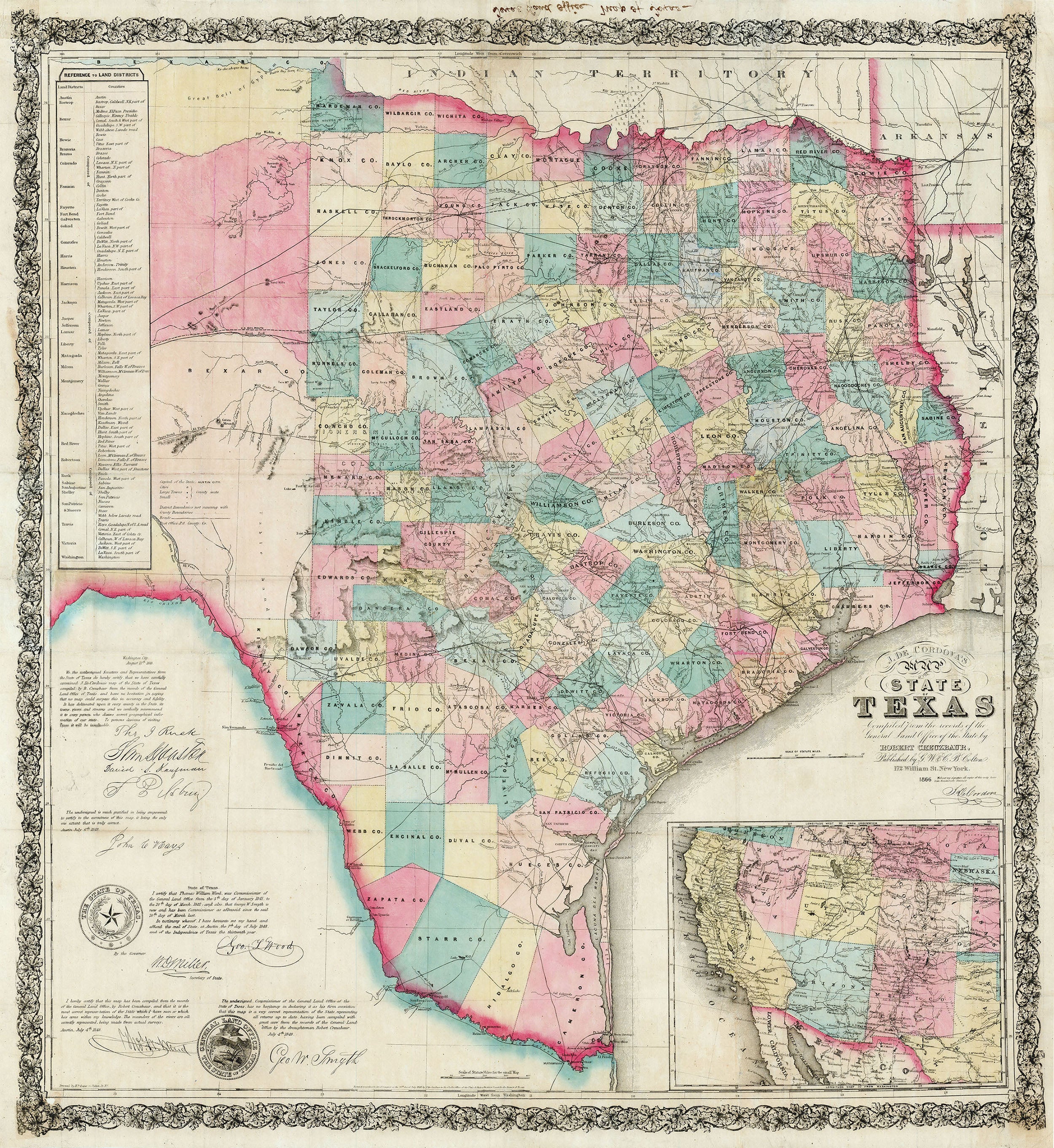
Fine Example of De Cordova’s Map of Texas, Scarce Reconstruction Issue
Hand-colored lithographed map of the state of Texas. Shows counties, cities and towns, roads, rivers, Native American villages. Decorative border, with an untitled inset map of the western U.S. from at lower right; north from the Dakotas and south to New Braunfels and Fredericksburg, Texas; west to the Pacific Coast, from San Diego to Southern Oregon. With state and land office seals of the State of Texas, scale at 10 miles to the inch. Table of land districts at upper left with corresponding counties. Facsimile signatures of Governor, Secretary of State, etc/Land Office officials, legislators, etc. Contemporary manuscript notation in the top margin (verso) "Texas Land Office, Map of Texas"; presumably in use at the Texas General Land Office soon after its printing in New York.
Jacob De Cordova came to Texas in 1837 and quickly became one of the new Republic’s key promoters. He was responsible for a number of influential pamphlets and guidebooks, and most famously, the first (1849) edition of his eponymous map. Hoping to cash in on the expected land boom following the Mexican War, De Cordova commissioned Robert Creuzbaur, an employee of the Texas General Land Office to compile the 1849 edition from the agency’s records. The result is this very detailed and accurate map, here in its 5th Colton state. De Cordova published the map in Houston about five times between 1849 and 1854, and in 1855 Colton bought the map from De Cordova, and republished in New York on another five occasions. This issue is the first to be released after the Civil War and incorporates additional information in the western parts of Texas, as people poured out of the Southern States into Texas to establish new lives.
Rarity: Scarce, with few examples of the 1866 being offered previously, not in the Library of Congress, (Phillips, America), or in the Rosenberg Library, (Taliaferro); and not in University of Texas at Arlington, which has only the 1849 edition. One 1866 example held at Texas State Archives, one at University of Houston, and others.
References: Wheat 609 (1849 edition); Ristow p.459; Taliaferro 295, Phillips, A List of Maps of America in the Library of Congress
Condition
Professional restoration expertly addressing old fold lines and a few small holes along some folds with archival tissue backing. Original outline and wash color, refreshed. Excellent.