
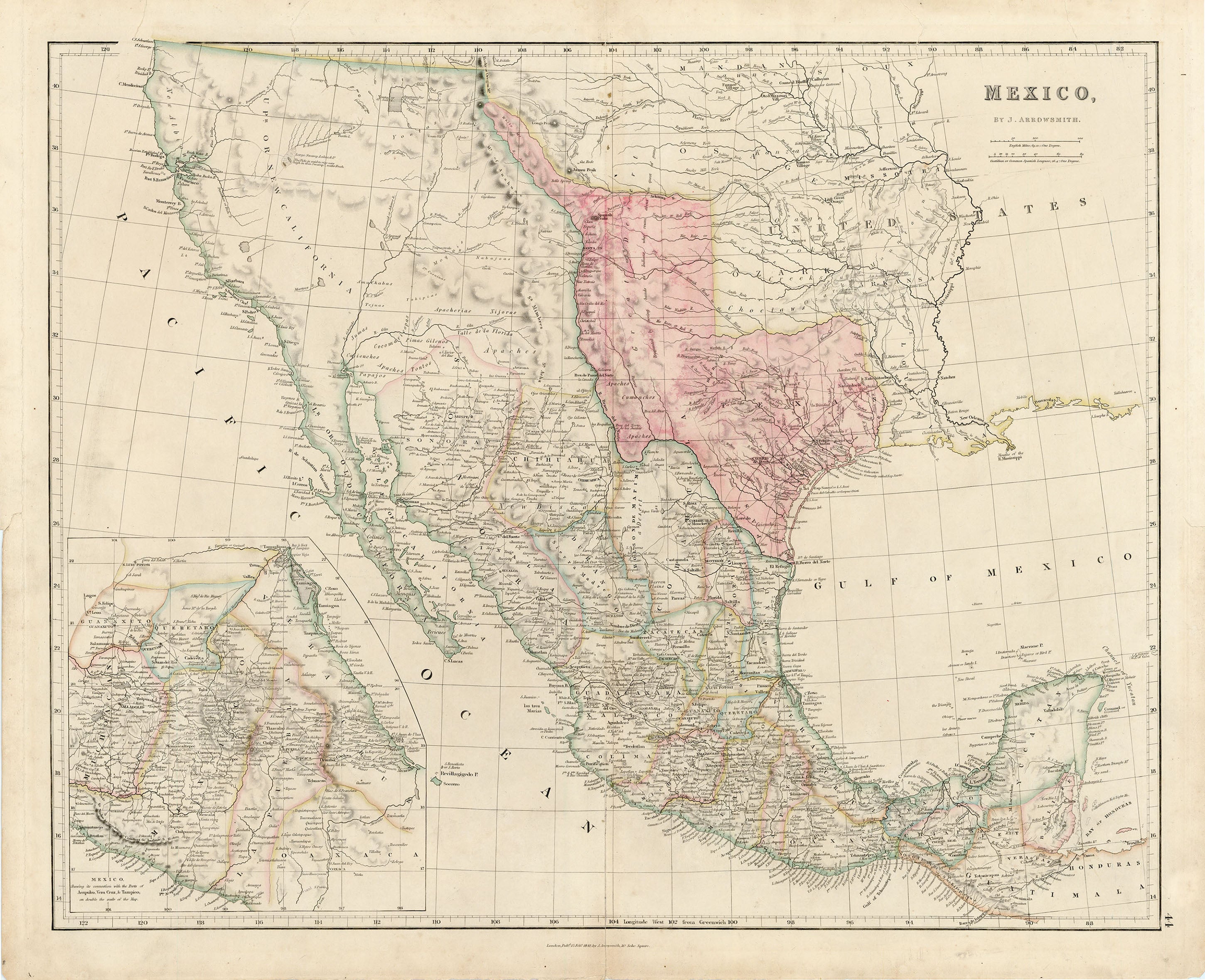
- Title: Mexico
- Author: John Arrowsmith
- Date: 1842
- Medium: Hand-colored engraving
- Condition: Excellent - contemporary outline color, retouched, minor soiling primarily confined to the margins. Skillful archival repairs to a 4 1/4" centerfold separation at bottom and another one that just crosses the neatline at top, as well as to a few edge tears, including one that enters 1/2" into the map image at top.
- Inches: 23.6 x 18.9 [Image]
- Centimeters: 59.94 x 48.01 [Image]
- Product ID: 317042
The Republic of Texas at its Greatest Extent
Published in The London Atlas of Universal Geography, this edition of Arrowsmith's southwestern United States, Texas, and Mexico shows the Independent Republic of Texas in the Emory configuration, with its southern and western borders touching the Rio Grande (R. Bravo del Norte). Very few Texas settlements are listed; Houston is not among them, though Harrisburg, S. Antonio de Bexar, S. Felipe de Austin, Nacogdoch, and Brazoria are.
Texas's border follows the 100th parallel to the Arkansas River. In Upper (or New) California, there is an American Fur Co. Depot on the eastern shore of Youta, or the Great Salt Lake. In New Mexico, the Great Spanish Road stretches from the Red River on the Texas boundary to Santa Fe, and then heads south through the length of Mexico. A large inset on double the main map's scale depicts central Mexico, centered on Mexico City and showing the important ports of Acapulco, Vera Cruz, and Tampico. Scale in English miles (69.12 = One Degree), and Castilian or common Spanish Leagues (26.4 = One Degree).
Texas's borders here reflect an interesting period in the state's history. Except for the possible claim of the Rio Grande as the Louisiana Purchase's western boundary, Texas's declared western boundary held no significance in global relations (and very little in its relations with Mexico) prior to 1836, the year Texas gained independence. In 1721, the Medina River was considered the boundary between Texas and Coahuila, and by 1811 the Nueces River had become the boundary between Texas and Tamaulipas.
As hostilities rose within the Mexican State of Coahuila y Tejas beginning in 1835, Mexico chose to intervene directly, sending forces led by General (and President) Antonio López de Santa Anna to calm the unrest. On April 21, 1836, the forces of the Mexican army led by Santa Anna were handed a decisive defeat by the Texians at the Battle of San Jacinto. Santa Anna attempted to flee, but was taken prisoner the following day. On May 14, Santa Anna signed two peace treaties with the newly formed Republic of Texas. The public treaty consisted of ten articles; a second, secret treaty contained six additional articles and was to be carried out when the public treaty had been fulfilled. Provisions of the secret treaty bound the Mexican army of Santa Anna to retreat beyond the Rio Grande and Texas not to claim land beyond that river. Thus was cemented Texas's claim to the Rio Grande as its western boundary.
The public treaty provided that hostilities would cease, that Santa Anna would withdraw his forces below the Rio Grande, and that Mexico would not take up arms again against Texas. In addition, Santa Anna pledged to restore property that had been confiscated by the Mexicans, and both sides promised to exchange prisoners on an equal basis. The Texans would also send Santa Anna back to Mexico without pursuing the retreating Mexican troops. In the secret agreement, the Texans agreed to release Santa Anna immediately in exchange for his pledge to use his influence to secure Mexican recognition of Texas independence. Santa Anna would not only withdraw all troops and not take up arms against Texas again, but would arrange for a favorable reception by the Mexican government of a Texas mission and a treaty of commerce.
On May 26, General Vicente Filisola began withdrawing Mexican troops in fulfillment of the public treaty. However, the Texas army blocked Santa Anna's release by the Texas government. Moreover, the Mexican government refused to accept the treaties on the grounds that Santa Anna had signed them as a captive, under duress. Since the treaties had now been violated by both sides, they never took effect. Mexico was not to recognize Texas independence until the Mexican-American War was settled by the Treaty of Guadalupe Hidalgo in 1848.
On December 19, 1836, the First Congress of the Republic of Texas declared the southern and western boundary of Texas to be the Rio Grande from its mouth to its source, and thence a line due north to the forty-second parallel. The Texan Santa Fe expedition of 1841 was an unsuccessful attempt to assert Texas authority in the New Mexico area embraced in that land claim.
Under the threat of war, the United States had refrained from annexing Texas after the latter won independence from Mexico in 1836. But, in 1844 President John Tyler (1790-1862) restarted negotiations with the Republic of Texas, culminating with a treaty and subsequently annexation in 1845. Texas claimed the same western limits after annexation as before, including lands in Colorado. The treaty of Guadalupe Hidalgo (1848) affirmed the Rio Grande boundary to El Paso as Texas's international boundary. However, the Texas claim to parts of Wyoming, Kansas, Colorado, and New Mexico, then occupied by United States troops, remained in dispute. Texas decreed a county, Santa Fe County, to include part of the area, but the people of New Mexico protested this claim. After prolonged debate in Congress and the Texas newspapers and near-armed dispute, an adjustment was reached in the Compromise of 1850. The compromise line ran the Texas western boundary from El Paso east along the thirty-second parallel to the 103d meridian, up that meridian to 36°30" latitude, and along that line to the 100th meridian, thence down the 100th meridian to the Red River, giving us Texas’ present boundaries.
John Arrowsmith (1790–1873) was born at Winston, County Durham England. He was the nephew of Aaron Arrowsmith, the celebrated and highly accomplished English cartographer. In 1810 he joined his uncle in the cartography business. After his uncle died in 1823, the family firm was carried on by his sons Aaron and Samuel Arrowsmith, and John began working on his own. The Arrowsmiths were founding members of the Geographical Society of London in 1830. The junior Aaron left the family firm in 1832, and upon the death of Samuel in 1839, John merged it into his own successful business, achieving acclaim on par with his uncle for his scrupulous research and high production value.
Arrowsmith spent the years after his uncle's death preparing maps for his iconic London Atlas of Universal Geography, the first edition of which was published in 1834 with 50 maps. He published subsequent editions, adding and removing maps, and growing the atlas to 72 in one late edition. The atlas continued to be published after his death, the rights to publish the maps having been acquired by Edward Stanford in 1874.