
- Title: A New and Exact MAP OF AMERICA laid Down from the latest observations and Discoveries | Sold by J. Bowles at the Black Horse in Cornhill
- Author: John Bowles
- Date: c.1730
- Condition: See description
- Inches: 23 x 38
- Centimeters: 58.42 x 96.52
- Product ID: 308258
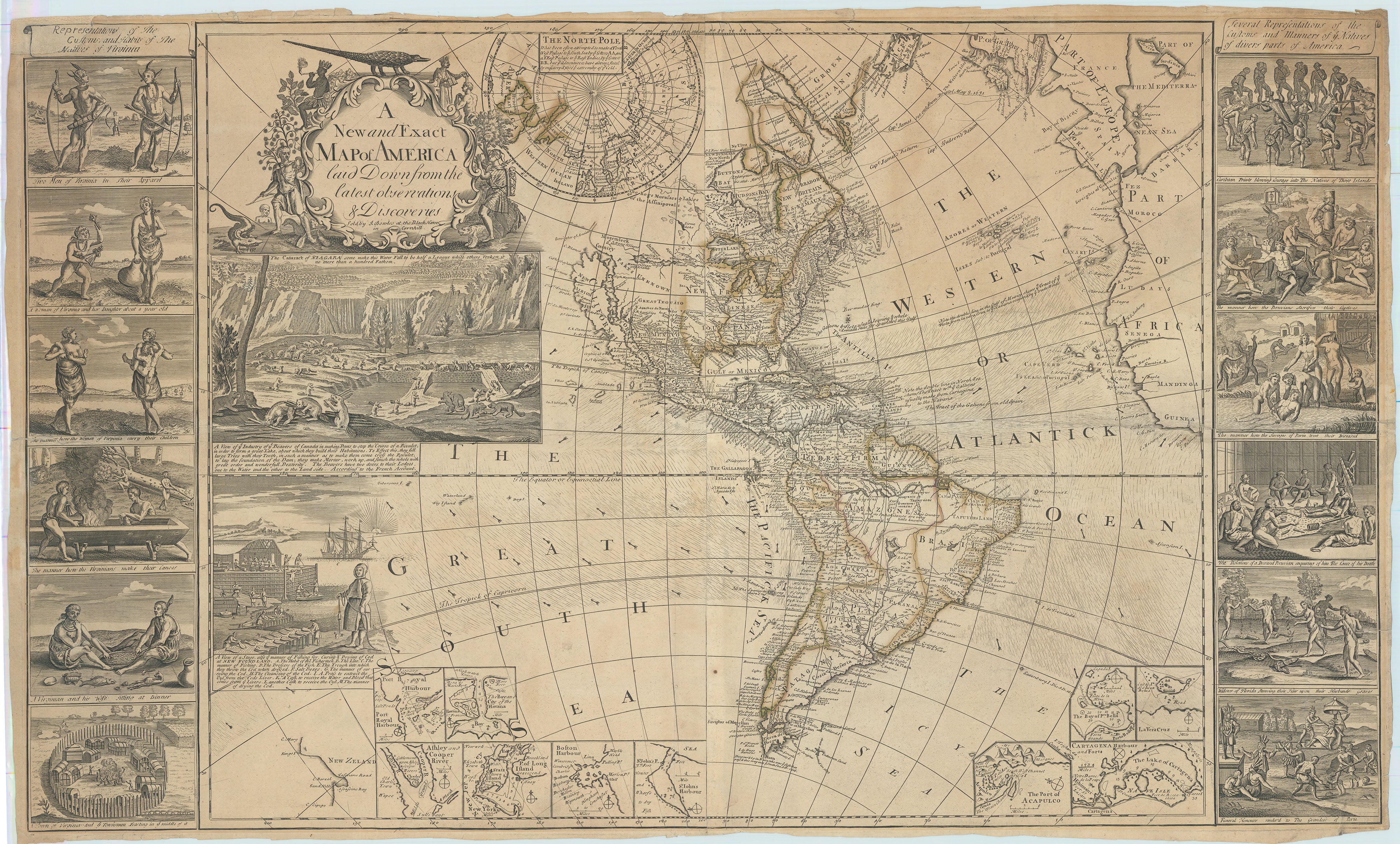
First Appearance of Rare Map of America?
Supremely rare map of the Western Hemisphere incorporating the intellectual efforts of Herman Moll, whose plates were purchased by the Bowles after Moll’s death in 1732. The nomenclature for the Atlantic and Pacific Oceans are identical to Moll’s world map. The map depicts the Western Hemisphere on the Mercator Projection, a method devised by cartographer Gerard Mercator (1512-1594) to represent the three-dimensional globe in two dimensions.
In the upper right, Bowles uses the Moll inset of ‘The North Pole’ showing the theoretical locations of the Northwest and Northeast Passages through the Arctic, although he updates the language from Moll’s original:
It has often been attempted to make a Northwest passage to ye South Seas by ye Letter AA, and a NEast Passage to ye East Indies by ye Letters B.B. but ye Adventurers have always fatally miscarried thro’ ye extremity of ye Cold.
Related to this, the primary map shows an inlet titled the ‘Streights of Annian’ (the Strait of Anián) in the approximate location of the present-day Pacific Northwest. This legendary strait, which first appeared on maps in the mid-sixteenth century, supposedly divided the Asian and North American continents and was thought to be the Northwest Passage long sought after by navigators. In 1728, explorers located the strait, which we know today as the Bering Strait; however, due to limitations in maritime technology and the region’s heavy ice, further discovery would wait for the great late eighteenth century English, French and Russian explorers. Bowles repeats other Moll inaccuracies, including California as an island, a concept debunked nearly 30 years before, but avoids more controversy by omitting the Lake of the West and showing much of the Pacific Northwest as blank space, awaiting the voyages of Cook, Vancouver, and Perouse who will fill in the blanks by the end of the Eighteenth Century.
Bowles borrows again from Moll with depictions of the famous beaver scene and cod fishing industry, which were borrowed in turn by Moll from de Fer’s grand wall map of the Western Hemisphere. Ten insets provide granular detail of New World ports; Port Royal, Havana, Charlestown, Long Island, Boston, St. John’s, Acapulco, Portobello, Cartegena, and Vera Cruz. Multiple references to Spanish treasure fleets adorn the Atlantic. Sir Edmond Halley’s ocean current theory, lifted again form Moll, adorns the equatorial regions of the Atlantic and Pacific oceans.
The side panels are essentially the work of de Bry from his Grand Voyages, an odd choice nearly two centuries out of date. On the left of the map Bowles correctly identifies de Bry’s Representations of the Customs and Habits of the Natives of Virginia, while the descriptions for the individual panels on the right bear slight correlation to the images depicted, again from de Bry. This certainly calls into question Bowles’ intellectual rigor and quality control.
Background on Creator
John Bowles (c. 1701-1779) was a notable English print seller and publisher active during the 18th century. Born around 1701, Bowles played a significant role in the London print trade, establishing himself as a prominent figure in the publishing industry. He was part of the Bowles family, which included several generations involved in the map and print business. John Bowles, along with his brother Thomas Bowles, inherited the map and print selling business from their father, Thomas Bowles the Elder.
John Bowles was particularly known for his involvement in producing and selling maps, prints, and atlases. The Bowles family's shop, located on Cornhill in London, became a well-known hub for cartography and prints during the 18th century. John Bowles continued the family tradition of publishing maps and prints, contributing to the dissemination of geographical knowledge and visual representations of various subjects. The Bowles firm was recognized for its commitment to quality and accuracy in mapmaking, earning them a reputable standing among contemporaneous cartographers and printmakers.
Throughout his career, John Bowles maintained close ties with other significant figures in the London print trade. His collaborations with engravers, artists, and fellow publishers contributed to the production of a wide range of printed materials, from maps to decorative prints. John Bowles's legacy extends beyond his own contributions as a publisher; it reflects the bustling and competitive atmosphere of the 18th-century London print industry, where individuals like him played crucial roles in shaping the visual culture of the time.
The Bowles family played a prominent role in the London map and atlas trade for almost 150 years, from the patriarch Thomas I whose efforts began in 1683 through the career of his great-great-grandson Henry Carrington Bowles, which concluded in 1832.
Rarity
First time offered in commerce? A similarly titled map was offered by London bookseller Frances Edwards, Ltd. In 1972 but titled Printed for J Bowles & Son at the Black Horse in Cornhill, suggesting a later date, after c. 1752. One institutional copy held at the Bibliotheque Nationale de France.
Condition
A dark impression, evenly age toned throughout, uneven margins with chipping, occasional staining, old but expertly repaired tears in central fold extending 3 inches at left and 14.5 inches at right along central horizontal fold. A few letters and portion of scroll at upper right in facsimile. Acceptable condition for a very rare map.
References
Tooley’s Dictionary of Mapmakers, 1999; BnF on-line, University of Pennsylvania Library on-line, both accessed 1-25-2024.