
- Title: Mexico
- Author: J. Arrowsmith
- Date: 1840
- Condition: See description
- Inches: 27 x 21.5 [Image]
- Centimeters: 68.58 x 54.61 [Image]
- Product ID: 308251
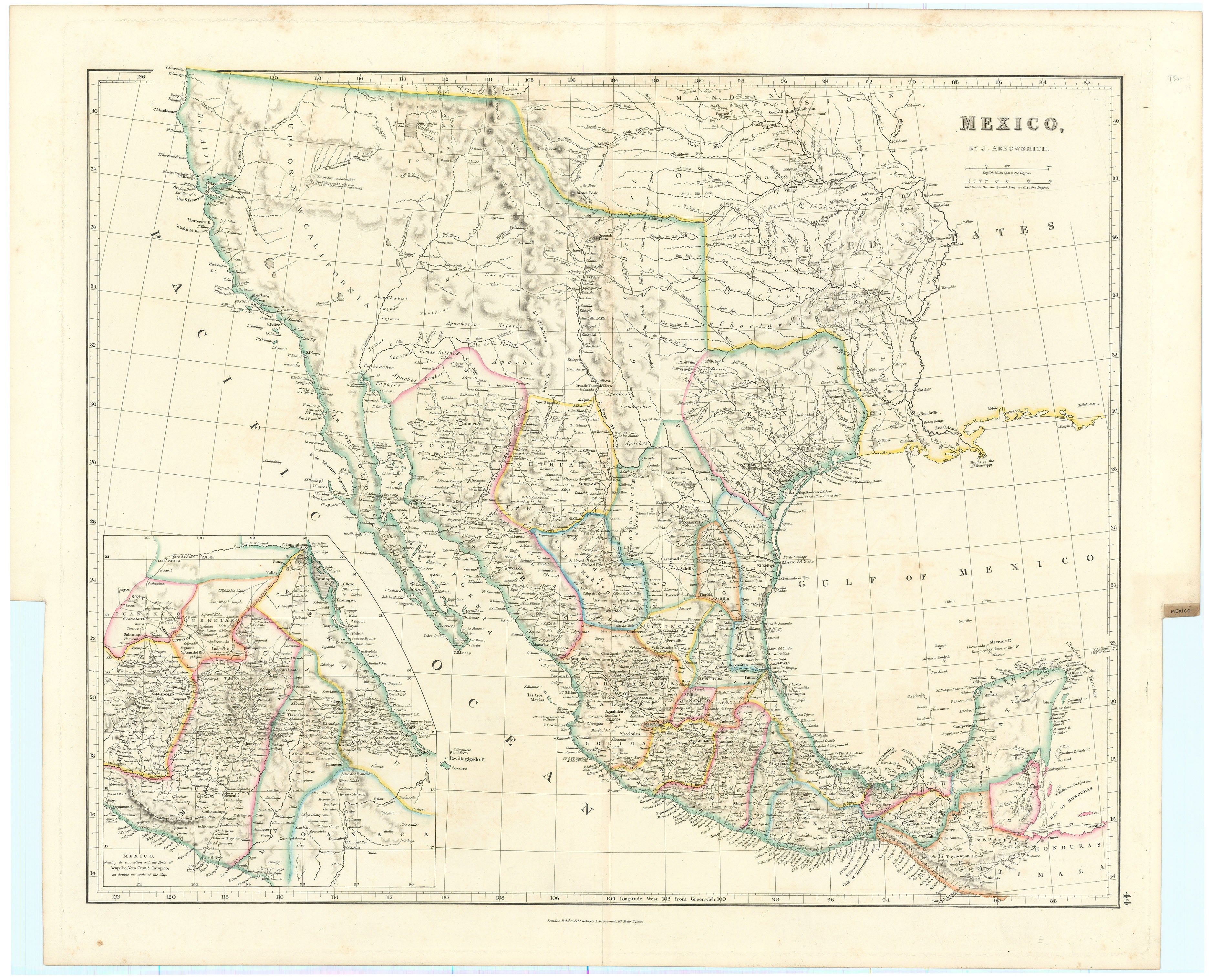
Border Claims and Counterclaims and the Secret Treaty of Velasco
Texas’ western border is drawn to the headwaters of the Nueces, then arcs gracefully if fancifully to the northeast, meeting the Red River at the 100th meridian, a border never recognized by Texas as a Republic or state. In Upper or New California, there is an American Fur Co. Depot on the eastern shore of Youta or the Great Salt Lake. In New Mexico, the Great Spanish Road is shown from the Red River on the Texas boundary to Santa Fe, and then heading south through the length of Mexico. A large inset, on double the main map scale depicts central Mexico, centered on Mexico City and showing the important ports of Acapulco, Vera Cruz and Tampico. Scale in English miles (69.12 = One Degree), and Castilian or common Spanish Leagues (26.4 = One Degree).
The Texas borders reflect an interesting period in the history of Texas. Except for the possible claim of the Rio Grande as the western boundary for the Louisiana purchase, the western boundary of Texas had no significance in international relations and practically no mention in Mexican interstate relations before Texas independence in 1836. In 1721 the Medina River was considered the boundary between Texas and Coahuila; in 1811 the Nueces River was the boundary between Texas and Tamaulipas. As internal elements within the Mexican State of Coahuila y Tejas began to agitate for independence, hostilities heated up in 1835, leading to direct military intervention by the Mexican army, led by General (and President) Antonio López de Santa Anna.
On April 21, 1836, the forces of the Mexican army led by Santa Anna were handed a decisive defeat by the Texians at the Battle of San Jacinto. Santa Anna attempted to flee but was taken prisoner the following day. On May 14, Santa Anna signed two peace treaties with the newly formed Republic of Texas. The Public Treaty of Velasco consisted of ten articles; a second, Secret Treaty of Velasco consisted of six additional articles. The secret agreement was to be carried out when the public treaty had been fulfilled. Provisions of the secret treaty bound the Mexican army of Santa Anna to retreat beyond the Rio Grande and Texas not to claim land beyond that river. Thus, the Texas claim to the Rio Grande as its western boundary sprang to life.
The public treaty provided that hostilities would cease, and that Santa Anna would withdraw his forces below the Rio Grande and not take up arms again against Texas. In addition, he also pledged to restore property that had been confiscated by the Mexicans. Both sides promised to exchange prisoners on an equal basis. The Texans would send Santa Anna back to Mexico and would not pursue the retreating Mexican troops. In the secret agreement, the Texans agreed to release Santa Anna immediately in exchange for his pledge to use his influence to secure Mexican recognition of Texas independence. Santa Anna would not only withdraw all troops and not take up arms against Texas again but would arrange for a favorable reception by the Mexican government of a Texas mission and a treaty of commerce. The Texas border would be the Rio Grande.
On May 26, General Vicente Filisola began withdrawing Mexican troops in fulfillment of the public treaty. However, the Texas army blocked Santa Anna's release by the Texas government. Moreover, the Mexican government refused to accept the treaties on the grounds that Santa Anna had signed them as a captive, under duress. Since the treaties had now been violated by both sides, they never took effect. Mexico was not to recognize Texas independence until the U.S.-Mexican War was settled by the Treaty of Guadalupe Hidalgo in 1848.
On December 19, 1836, the First Congress of the Republic of Texas declared the southern and western boundary of Texas to be the Rio Grande from its mouth to its source and thence a line due north to the forty-second parallel. The Texan Santa Fe expedition of 1841 was an unsuccessful attempt to assert Texas authority in the New Mexico area embraced in that land claim.
Under the threat of war, the United States had refrained from annexing Texas after the latter won independence from Mexico in 1836. But in 1844, President John Tyler (1790-1862) restarted negotiations with the Republic of Texas, culminating with a treaty, and annexation in 1845. Texas claimed the same western limits after annexation as before, including lands in Colorado. The treaty of Guadalupe Hidalgo (1848) affirmed the Rio Grande boundary to El Paso as the international boundary, but the Texas claim to Parts of Wyoming, Kansas, Colorado, and New Mexico, then occupied by United States troops, remained in dispute. Texas decreed a county, Santa Fe County, to include part of the area, but the people of New Mexico protested the Texas claim. After prolonged debate in Congress and the Texas newspapers and near-armed dispute, an adjustment was reached in the Compromise of 1850. The compromise line ran the Texas western boundary from El Paso east along the thirty-second parallel to the 103d meridian, up that meridian to 36°30" latitude, and along that line to the 100th meridian, thence down the 100th meridian to the Red River, giving us Texas’ present boundaries.
Background on Creator
John Arrowsmith (1790–1873) was the nephew of the renowned Aaron Arrowsmith, and the Arrowsmith family was among the most respected and influential cartographers of the nineteenth century. He stands as a noteworthy English mapmaker renowned for his cartographic expertise. Born in Durham, England, Arrowsmith entered the field of mapmaking under the guidance of his uncle, Aaron Arrowsmith, a respected cartographer of his time. John Arrowsmith gained recognition for his meticulous and detailed maps, particularly those focusing on the exploration and geography of various regions across the globe. His dedication to accuracy and the incorporation of the latest geographical discoveries contributed significantly to his reputation in the cartographic community.
Arrowsmith's notable works include the London Atlas, first published in 1834, which featured a collection of finely crafted maps covering different continents and regions. The atlas showcased Arrowsmith's commitment to precision and included updates reflecting the latest information available during this era of exploration and scientific advancements. His maps were characterized by clear, concise depictions of topography, coastlines, and political boundaries, making them valuable resources for navigators, scholars, and the general public alike.
As a prominent figure in the 19th-century mapmaking scene, John Arrowsmith established a legacy that endured beyond his lifetime. His maps were esteemed for their accuracy and attention to detail, contributing to the broader understanding of the world's geography during a period marked by exploration and expansion. Arrowsmith's influence on the cartographic field and his commitment to producing high-quality, informative maps solidify his place among the distinguished mapmakers of his era.
In 1841, John Arrowsmith published a map of the Republic of Texas, which was the best depiction of Texas available in Europe during the Republic and annexation period.
Principal Authorities
Streeter Texas 1373A, Wheat 451, Martin & Martin 32, Texas State Historical Association Handbook
Condition
Neatly reinforced on verso at the center for where it was formerly bound in an atlas. Lightly toned.