
- Title: Colton's New Map of the State of Texas
- Author: G. W. Colton
- Date: 1874
- Condition: See description
- Inches: 35.75 x 33.75 [Image]
- Centimeters: 90.81 x 85.73 [Image]
- Product ID: 308253
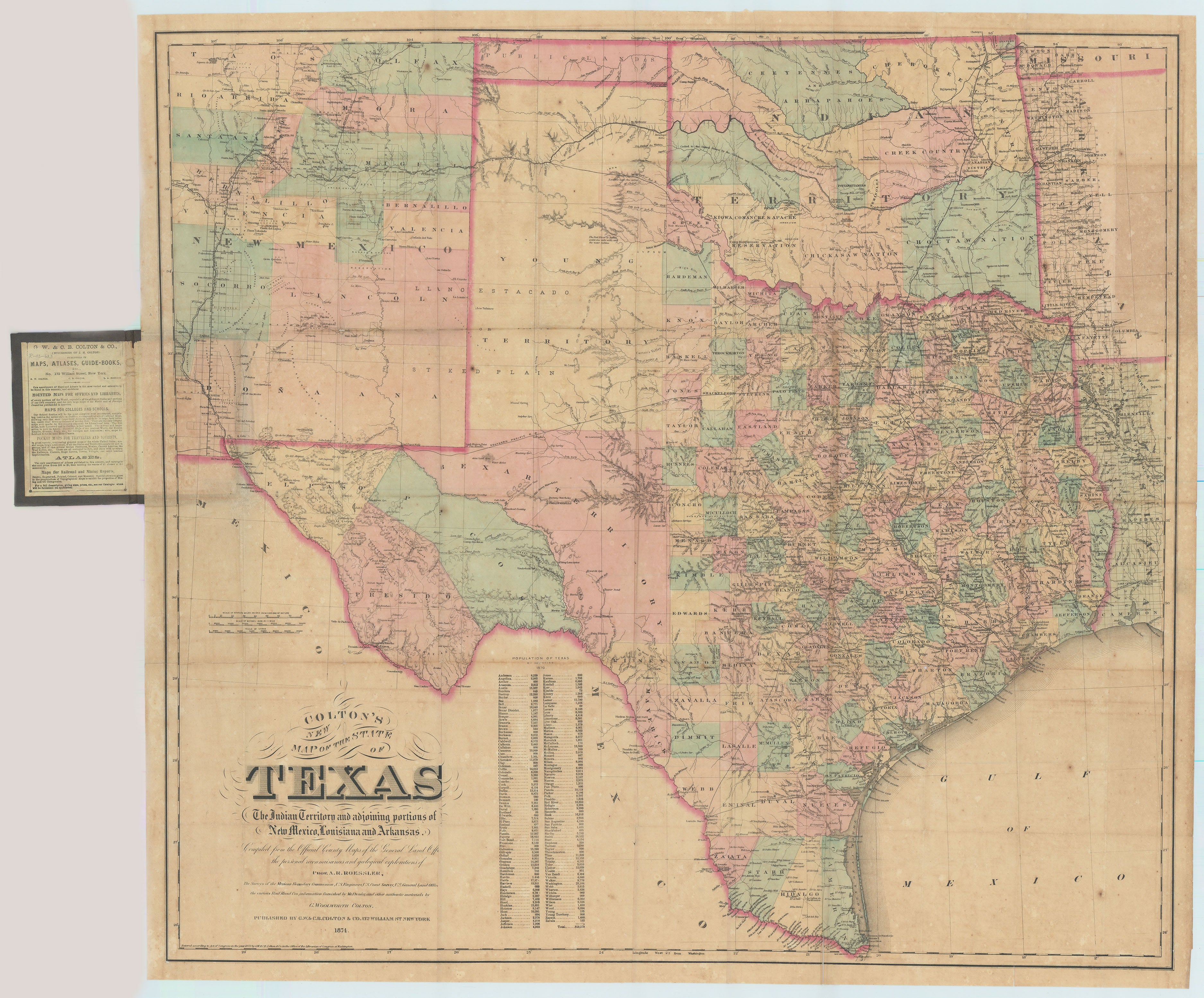
Splendid Folding Map of Texas, of the Utmost Rarity
Texas Shown on the Eve of Rapid West Texas County Formation
Lithograph map on two sheets of joined bank note paper, original hand color in wash and outline, within an ornamental border. Compiled from the Official County Maps of the General Land Office, the personal reconnaissance and geological explorations of Prof. A. R. Roessler, The Surveys of the Mexican Boundary Commission, U.S. Engineers, U.S. Coast Survey, U.S. General Land Office, the various Rail Road Cos. Information furnished by Mr. Pressler, and other authentic materials by G. WOOLWORTH COLTON. Entered According to Act of Congress in the Year 1872 by G. W. & C. B. Colton & Co. in the Office of the Librarian of Congress, at Washington. Folding into publisher's brown cloth covers: Colton's New Map of Texas New York G. W. & C. B. Colton & Co. lettered in gilt and with gilt lone star on upper cover, both covers blind-embossed with advertisement on the front pastedown. Housed in a modern quarter morocco slipcase.
Extremely rare pocket map of Texas, first issued in 1872, by one of the leading mapmakers of the nineteenth century. Because of the large scale, this map is quite detailed and shows the continuing westward settlement pattern in the State. The map has minute details of the rapidly growing areas of north, central, and east Texas. West Texas, still largely unsettled, remains separated into five large districts: El Paso, Presidio, Pecos, Bexar, and Young.
The state is shown divided into numerous counties. Reflecting a continuing controversy, Greer County in north Texas is still shown as part of the Lone Star State, even though it was eventually ceded to Oklahoma, although interestingly minus the red wash outline used elsewhere to depict the state’s borders. The superb detail includes Native American reservations, forts, mines, rivers and waterways, counties, towns, townships, and topographical features. With a table of population according to the 1870 census, by county. Washington County boasts the largest population at 23,104, while Harris County is second most populous with 17,375.x
The surrounding areas of New Mexico, Indian Territory, and western Louisiana are also shown in considerable detail. Mexico is shown in somewhat less detail, but the vital communication route to California across Tehuantepec, including the proposed canal and railroad, are shown.
The Colton firm specialized in highly detailed large-format maps like the one presented here, which depended heavily on Roessler and Pressler for source information.
Rarity
Prior to our offering, this issue of the pocket map (1874) has not appeared in commerce, although editions of 1872, 1873, 1882, and 1883 have. No editions on market since 2008.
Background on Creator
George Woolworth Colton (1827–1901) was an American map publisher and entrepreneur who played a significant role in the development of cartography during the 19th century. George Woolworth Colton worked alongside his father, Joseph Hutchins Colton, in the family's map publishing business. George Woolworth Colton's role in the company was instrumental, and he contributed to the success and growth of the business alongside his father. The Colton family's legacy in mapmaking spans generations, and their maps continue to be valued for their accuracy and historical significance.
Colton's contributions to the field of cartography extended beyond map publishing. He actively participated in the expansion of the railroad system in the United States during the 19th century, producing detailed railroad maps that played a crucial role in planning and development. His maps were widely used by travelers, businesses, and government agencies, contributing to the growth and connectivity of the nation. Colton's commitment to accuracy and innovation in mapmaking solidified his legacy as a prominent figure in American cartography, and his maps remain valuable historical artifacts that provide insight into the geographical and transportation landscape of the 19th century.
Despite facing challenges such as competition and economic downturns, Colton's map publishing company continued to thrive under his leadership. His dedication to excellence in cartography, coupled with a keen understanding of the evolving needs of his time, ensured the enduring success of G.W. Colton & Co. George Woolworth Colton's impact on the mapmaking industry and his role in shaping the cartographic landscape of 19th-century America make him a notable figure in the history of geography and business.
Condition
Map lightly toned overall, some short separations at folds, occasional tiny losses at fold intersections, a few minor archival reinforcements on verso. Excellent. Cloth case with slight damp-mottling to finish, but otherwise exceptionally well preserved and a rare survivor.
Should the collector wish to display the map framed, a light restoration may be appropriate.