
- Title: MAP OF THE CITY OF GALVESTON TEXAS JAN. 1904 COMPILED BY C.G. WELLS C.E.
- Author: C. G. Wells, CE
- Date: 1904
- Condition: See bottom of description
- Inches: 45.25 x 32.5 [Paper]
- Centimeters: 114.93 x 82.55 [Paper]
- Product ID: 308119
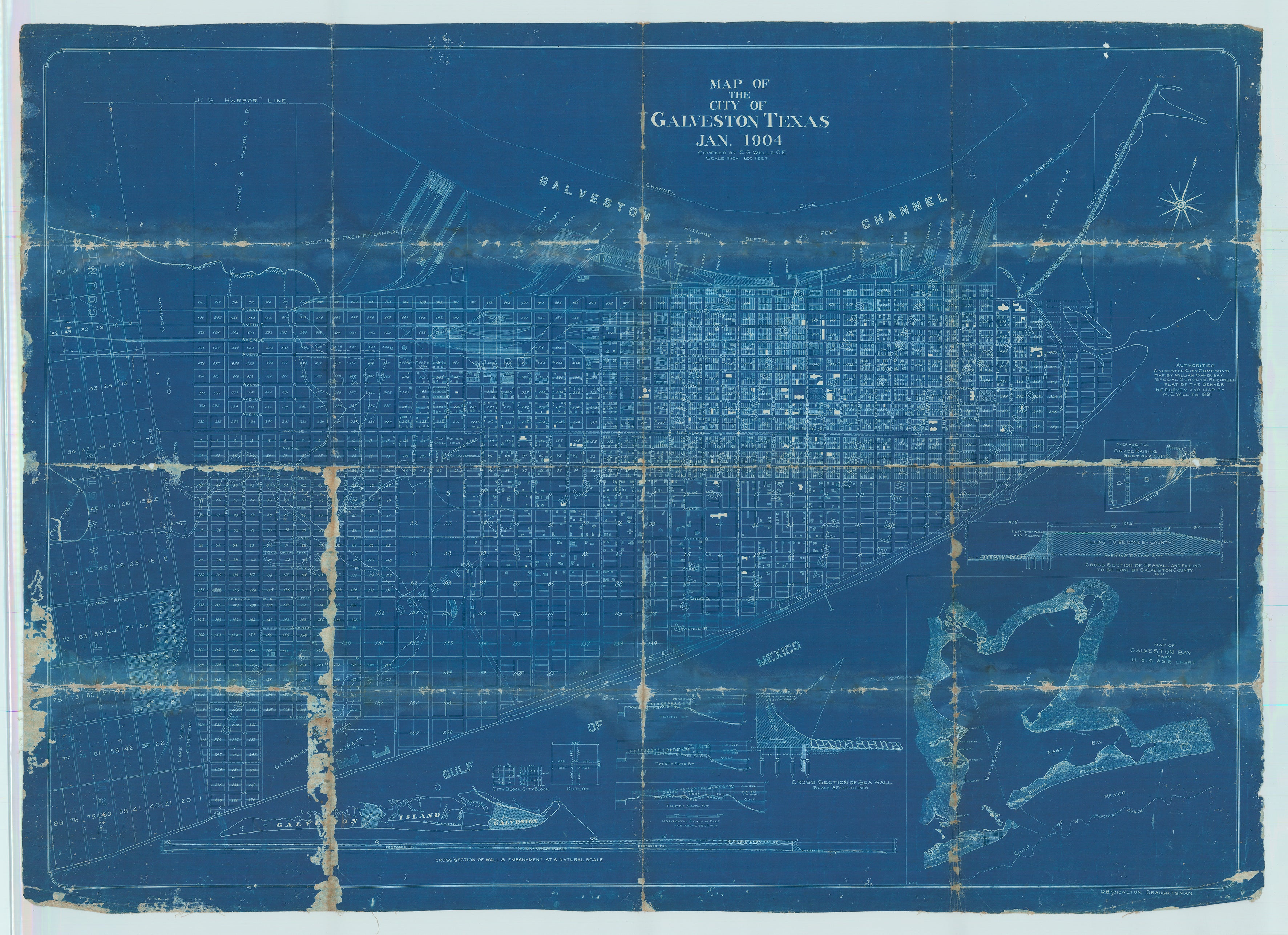
Only Known Example of Post Storm Galveston with Remediation Infrastructure
Cyanotype map showing Galveston Island with numerous insets of the seawall constructed after the hurricane of 1900. An absolute trove of historical data rendering the power of the storm into the authorities attempts to prevent anything like it ever happening again. Map legend describes authorities as
GALVESTON CITY COMPANY’S MAP BY WILLIAM SANDUSKEY | SPECIAL SURVEY’S | RECORDED PLAT OF THE DENVER RESURVEY | AND MAP BY W.C. WILLITS, 1891. Three incredible insets showing High Water in 1875, 1888 and 1900 at 10th, 25th and 39th street, with overlay of present surface of the ground, and proposed grade above, indicating the enormity of the land claimed by the raging Gulf of Mexico during the storm of 1900. Other insets include a view of the entire island at reduced scale, an inset of San Jacinto Bay, and detailed engineering renderings of the remediation plans the City of Galveston undertook to prevent another disaster; the seawall, city blocks and out lots, and proposed fill and embankment height cross section compared to current ground level.
At once a tragic and fascinating glimpse at the aftermath of the greatest natural disaster in American history. The unnamed Category 4 hurricane that struck Galveston on September 8, 1900 claimed as many as 10,000 lives and destroyed over 3,600 structures. Known simply as The Storm, it forever changed the trajectory of Galveston, Houston, and all of South Texas. The historic accounts of first hand witnesses to the mind-numbing power and destruction are incredibly chilling. Absolutely no-one was prepared for this event, and all who survived were forever scarred by the scale and magnitude of the hurricane’s destructiveness.
Indeed, a glimpse at the overall map of the island shows the path of destruction, with numerous structures shown north of Avenue M, a number of scattered structures north of Avenue P ½, and absolutely none south of Avenue N from the eastern most extent of the island west to 56th street, the City Limit at the time, with the exception of two ghostly structures at the intersection of 52nd Street and Avenue S. The thousands of structures and thousands of souls that were the lively residents of this area were all claimed by the storm, washed out to the gulf of Mexico, erased from history.
Raising the grade
The feat of raising an entire city began with three engineers hired in 1901 to design a means of keeping the gulf in its place. Along with building a seawall, Alfred Noble, Henry M. Robert and H.C. Ripley recommended the city be raised 17 feet at the seawall and sloped downward at a pitch of one foot for every 1,500 feet to the bay.
The first task required to translate their vision into a working system was a means of getting more than 16 million cubic yards of sand - enough to fill more than a million dump trucks - to the island, according to McComb.
The solution was to dredge the sand from Galveston's ship channel and pump it as liquid slurry through pipes into quarter-square-mile sections of the city that were walled off with dikes. Before the pumping could begin, all the structures in the area had to be raised with jackscrews. Meanwhile, all the sewer, water and gas lines had to be raised. By 1911, 500 city blocks had been raised, some by just a few inches and others by as much as 11 feet.
The Seawall
The most apparent of Galveston's efforts to prevent a repeat of 1900's devastation is the seawall, which today runs from just past Boddeker Drive on the east end to just past Cove View Boulevard on the west.
The current span of just more than 10 miles was built in six sections in a period of almost 60 years.
The oldest part of the seawall still visible runs from Sixth street to 39th street and was built between 1902 and 1904, he said. The original seawall ran from Eighth Street at the Galveston Wharf front south to Sixth Street and from Sixth west to 39th, as can be seen on the map. The seawall was expanded three times from 1905 to 1961.
The wall got its first real test in mid-August of 1915 when a hurricane of severity comparable to the 1900 Storm blew across the island. While much of the city was flooded and most of the structures outside the protection of the original wall were destroyed, those behind it fared well.
Rarity:
Exceedingly Rare. Three variant non-cyanotype examples printed by Clark and Court, Galveston Texas held at Rosenberg Library, University of Houston, and Harvard University Library. We cannot locate any copies ever having been offered at auction. Quite possibly a unique survivor.
Condition:
Laid to contemporary cartographic linen, folded with loss at folds (see photo above).
References:
Taliaferro III et. al. Cartographic Sources in the Rosenberg Library. McComb, Galveston: A History. Larson, Isaac’s Storm. Galveston County Daily News, accessed 2-28-2023: https://www.1900storm.com/orphanage.html.