
- Title: The Western Coast of Louisiana and the Coast of New Leon
- Author: Thomas Jefferys
- Date: 1775
- Condition: See description
- Inches: 28.25 x 21.25 [Sheet]
- Centimeters: 71.75 x 53.97 [Sheet]
- Product ID: 308249
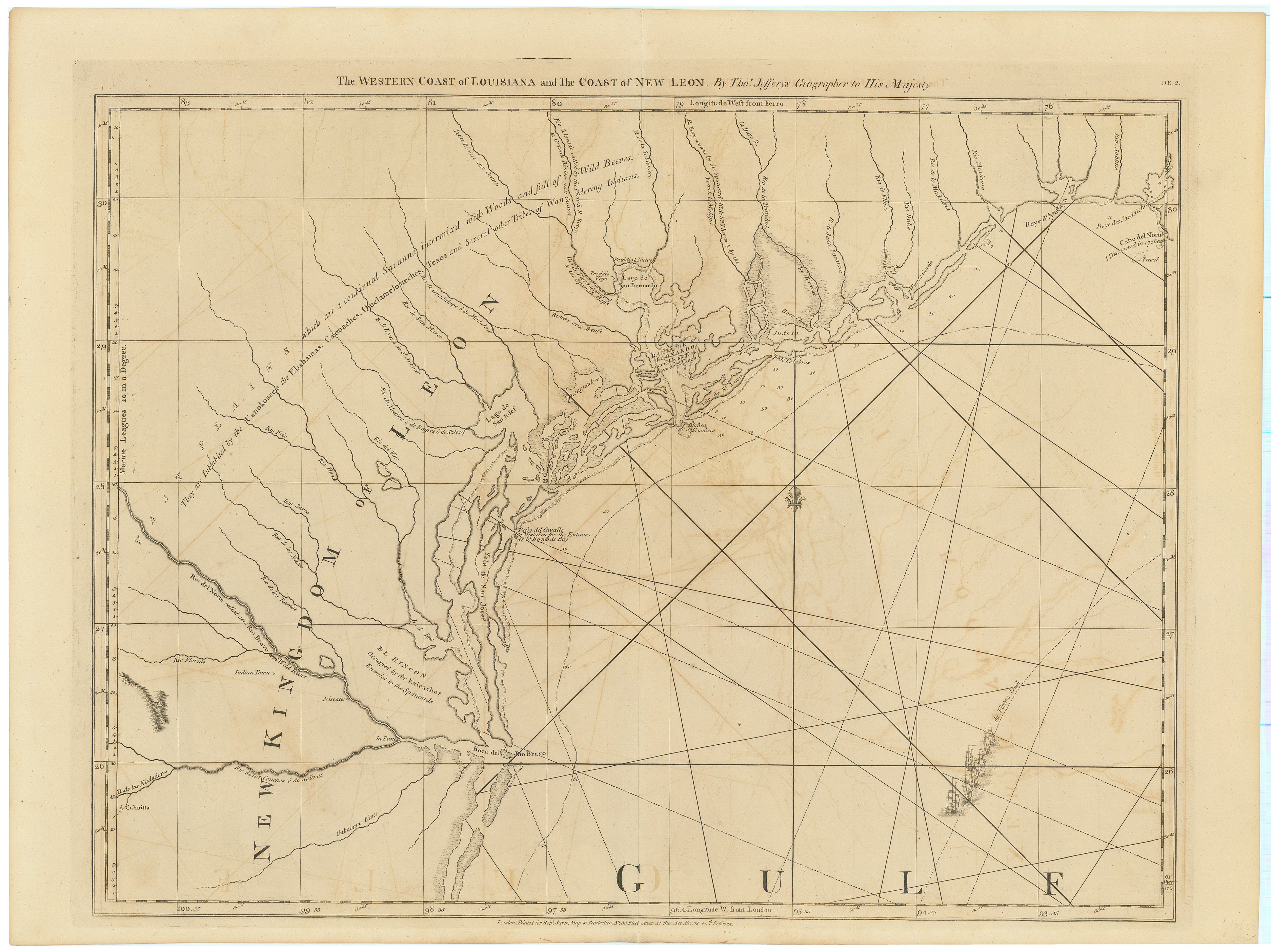
First issue of Jefferys Influential Map Depicting the Coastline of Texas and Louisiana
Taliaferro writes, "This map is remarkable both for its large scale and for the poor state of its geography. No previous printed map had focused so closely on the Texas coast, which makes the depiction's jumbled nature even more striking... Jefferys was probably one of the world's leading, most respected cartographers in 1775 and his ignorance of the coast's geography is testimony to the obscurity of 18th-century Texas." The Spanish Empire viciously protected its maps, making it even more difficult for foreign cartographers to accurately depict its colonies.
The map received wide circulation and according to Streeter was the most reputable authority on Texas for at least twenty-five years. Martin & Martin write, "Britain's keen interest in North America was reflected in Jefferys' well-known American Atlas, his North American Pilot, and his West India Atlas, in which he published this chart of the Texas coastline. Like other commercial map makers of the day, competition and overhead forced him to operate on a low budget, which often meant reliance on secondary sources and even plagiarism. But for his charts and maps depicting Spanish territories, however, Jefferys relied heavily on sketches and other maps captured by the British from Spanish warships."
Perhaps Jefferys can be forgiven his ambition exceeding geographic reality. After all, the Texas coastline was not fully revealed until The United States Coast Survey began inching toward Texas in the early 1840’s, revealing a more accurate understanding of this complex, shifting landscape. Led by Alexander Dallas Bache (a great-grandson of Benjamin Franklin) the U.S. Coast Survey expended massive effort to document much of the coast of Texas in the 1840’s and 1850’s. Although Commodore Edwin Moore, Capt. George Simpton, and Capt. Perry W. Humphrey of the Texas Navy had made surveys and maps of the Texas coast, and engineers attached to Gen. Zachary Taylor's army had surveyed the section of the coast between Corpus Christi and Caballo Pass in 1845–46, the Coast Survey's charting of the Gulf Coast from Point Isabel (later Port Isabel) to Florida appears to have been the first scientific cartography of the coast of Texas.
Background on Creator
Thomas Jefferys (1719–1771) was a distinguished English geographer and cartographer who held the prestigious title of Geographer to the King. Born in Birmingham, England, Jefferys exhibited an early fascination with geography and mapmaking. His career flourished during the mid-18th century when he established himself as a leading figure in London's cartographic community. Renowned for his meticulous attention to detail and commitment to accuracy, Jefferys gained royal recognition, earning the appointment as Geographer to King George III in 1760.
Jefferys' cartographic contributions were extensive and diverse, covering a wide range of regions and topics. Notably, his maps of the American colonies, the West Indies, and Europe were highly regarded for their precision and thoroughness. During a period of significant exploration and expansion, Jefferys played a crucial role in providing accurate geographic information. His maps not only served practical navigational purposes but also contributed to the broader understanding of the world. Thomas Jefferys' legacy endures as a testament to his skill and dedication in the field of cartography, reflecting the advancements in geographical knowledge during a transformative era of global exploration.
Despite his influential role in mapping, Thomas Jefferys faced financial challenges throughout his life. Despite his significant contributions, he struggled with debts and was imprisoned for a brief period in 1762. Nevertheless, his impact on the world of cartography persisted, and his work continued to be appreciated long after his death in 1771. The legacy of Thomas Jefferys serves as a reminder of the intricate interplay between individual achievement, historical context, and the enduring value of accurate geographic representation.
Principal Authorities
Martin & Martin, Maps of Texas and the Southwest, 1513-1900, 21.
Condition
Toned throughout with light offsetting. Remnants from previous binding to the verso.