
- Title: Texas
- Author: T. G. Bradford
- Date: 1838
- Condition: See description
- Inches: 16 x 13 [Image]
- Centimeters: 40.64 x 33.02 [Image]
- Product ID: 308250
An Influential Early Map of an Independent Republic of Texas, After Stephen F. Austin’s Map
Beautifully displayed in one of The Antiquarium's museum-quality custom picture frames.
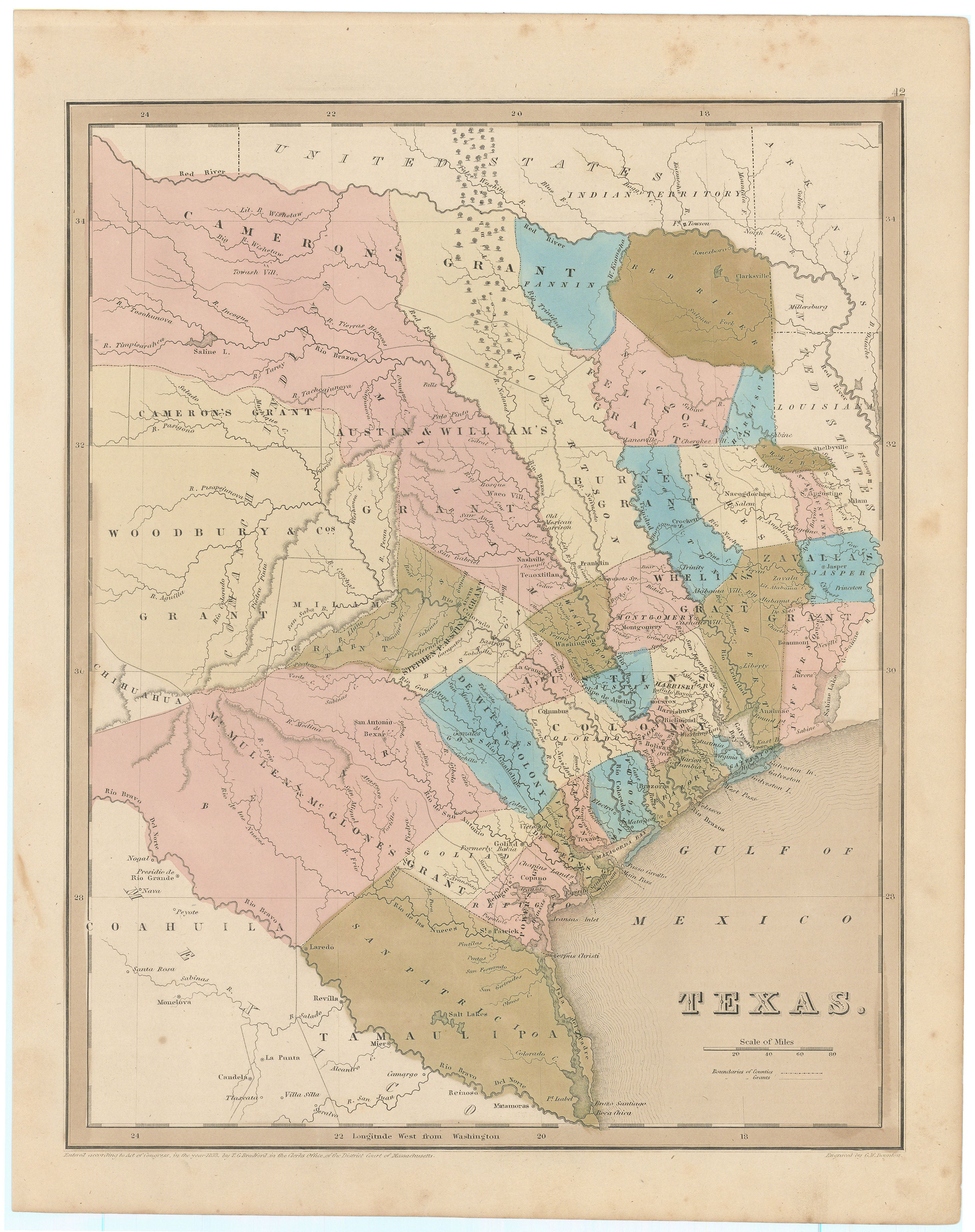
A fascinating early glimpse of the Republic of Texas, with various land grants shown in East and Central Texas, and Stephen F. Austin's colony shown in the center of the map due north of San Antonio de Bexar. Showing the young Republic sandwiched between the United States and Mexico, this map is from Bradford’s highly successful but scarcely seen Illustrated Atlas Geographical, Statistical and Historical, published in 1838.
There are at least six different versions of the Bradford map; all of them are from the atlases that Bradford published between 1835 and 1840. The earliest of the Texas maps came out in Bradford's 1835 atlas-small-format and with outline coloring. In 1838, Bradford revised his atlas to a larger format. He made the map of Texas larger and updated it to reflect new knowledge. This map and the next three large-format Bradford Texas maps have variations that occur in engraving; there are also differences in coloring, such as full color vs. outline color. The earlier versions show only land grants; the city of Austin is not yet included; and the Nueces River is the southwestern border. In the present version, county lines are superimposed over the land grants, new towns are presented (including Austin, established in 1839), and the Rio Grande is the southern border.
Bradford was the first maker of atlases to include a separate map for Texas. Martin & Martin write, "Bradford published a completely new atlas in 1838, in a larger format, and the map of Texas it contained was even more clearly patterned on Austin's. Aside from showing Texas as a separate country, the map and text Bradford inserted into his atlas is historically important for clearly demonstrating the demand in the United States for information about Texas during the Revolution and the early years of the Republic. It also serves to confirm the importance of Austin's map as source for that information."
Background on Creator
Thomas Gamaliel Bradford (1802–1887) was a distinguished American mapmaker and publisher known for his significant contributions to 19th-century cartography. Born in Boston, Massachusetts, Bradford's interest in maps and geography led him to establish himself as a prominent figure in the mapmaking industry during the mid-1800s. His career flourished as he became renowned for producing detailed and accurate maps of various regions, particularly focusing on the United States and its expanding western territories.
Bradford's most notable work includes his publication An Illustrated Atlas, Geographical, Statistical, and Historical of the United States and Adjacent Countries, which he first published in 1838. This atlas featured beautifully engraved maps accompanied by descriptive texts, providing a comprehensive overview of the United States during that period. Over the years, Bradford continued to update and expand his atlas to reflect the changing geopolitical landscape of the country. His commitment to accuracy and meticulous craftsmanship contributed to the widespread acclaim of his maps and atlases.
Throughout his prolific career, Thomas G. Bradford collaborated with several prominent engravers and mapmakers, ensuring the high quality and visual appeal of his works. His maps played a crucial role in documenting the growth and development of the United States during the 19th century. Today, the maps and atlases created by Thomas G. Bradford are highly sought after by collectors and historians, offering valuable insights into the geography and history of the United States during a transformative period in its expansion and development.
Principal Authorities
Martin & Martin, Maps of Texas and the Southwest, 1513-1900, 31.
Condition
Toned throughout with light foxing. Excellent.