
- Title: Map of Texas and the Countries Adjacent
- Author: W. H. Emory
- Date: 1844
- Medium: Hand-colored engraving
- Condition: Good - tide marks and repaired separations along issued folding (some reinstated paper in areas of significant loss), light foxing, large repaired tears in left and right margins, original hand-colored outlines, large horizontal tear along bottom margin
- Inches: 33 ¼ x 21 ½ [Image]
- Centimeters: 84.46 x 54.61 [Image]
- Product ID: 316062
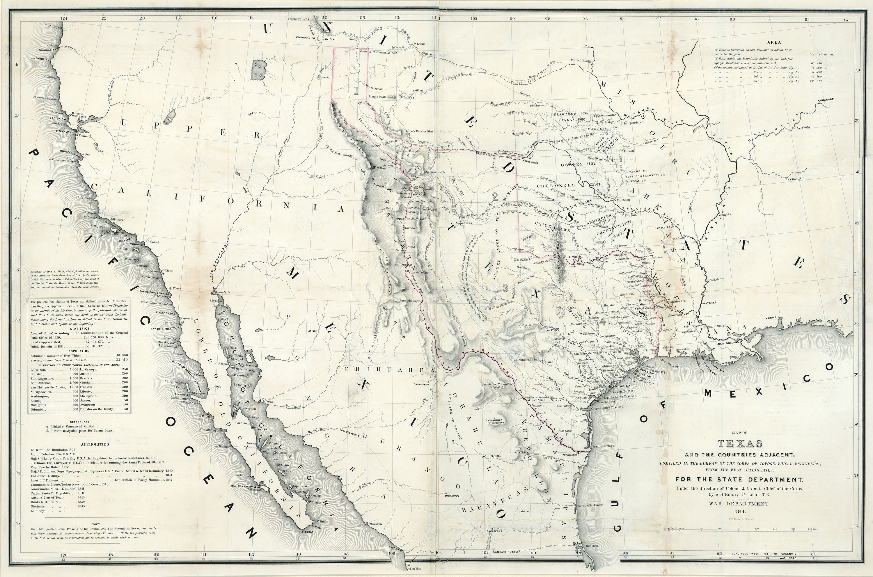
In 1844, the same year of the United States’ annexation of Texas, William H. Emory (1811-1887) published his Map of Texas and the Countries Adjacent. It showed the full extent of the Republic of Texas’s territorial claims (the so-called “stovepipe” configuration), and was the first chart to correctly delineate the boundaries set on December 19, 1836 by the Texas Congress. Emory’s robust depiction of Texas proved instrumental in garnering support for its annexation, as the idea of adding such a substantial stretch of territory to the United States appealed to many Americans. Inadvertently, the map also bolstered popular support for James K. Polk, who centered his presidential platform in the election of 1844 around Texas’s annexation.
Emory’s map shows most of the present-day southwestern United States and northern Mexico, and marks longitude from both the Greenwich and Washington Meridians. He labels the routes taken by the various explorers listed in the map’s bottom left corner, and also indicates the locations of cities, forts, major roads and trails, Native peoples, and topographical features such as Pike’s Peak. Many small Texas towns appear for the first time on this map.
Though Emory had never personally visited Texas, he relied on source material provided by the Corps of Topographical Engineers in Washington. These sources included Alexander von Humboldt (1769-1859), Zebulon Pike (1779-1813), S. H. Long (1784-1864), and J. C. Fremont (1813-1890), among others. In an attempt to synthesize such an array of sources, Emory often encountered conflicting information; most of his errors stem from efforts to reconcile these differences. In an attempt to remedy possible mistakes, he includes lengthy annotations listing his sources, explaining his decisions, and presenting alternate cartographic interpretations. In regards to the boundaries of Texas, he includes the following note:
The present Boundaries of Texas are defined by an Act of the Texian Congress, approved Dec: 19th: 1836, to be as follows: “Beginning at the mouth of the Rio Grande; thence up the principal stream of said River to its source, thence due North to the 42° North Latitude; thence along the Boundary Line as defined in the Treaty between the United States and Spain, to the beginning”