
- Title: Pocket Map of the State of Texas
- Author: C. W. Pressler & A. B. Langermann
- Date: 1879
- Condition: See description
- Inches: 26.5 x 25 [Image]
- Centimeters: 67.31 x 63.5 [Image]
- Product ID: 308254
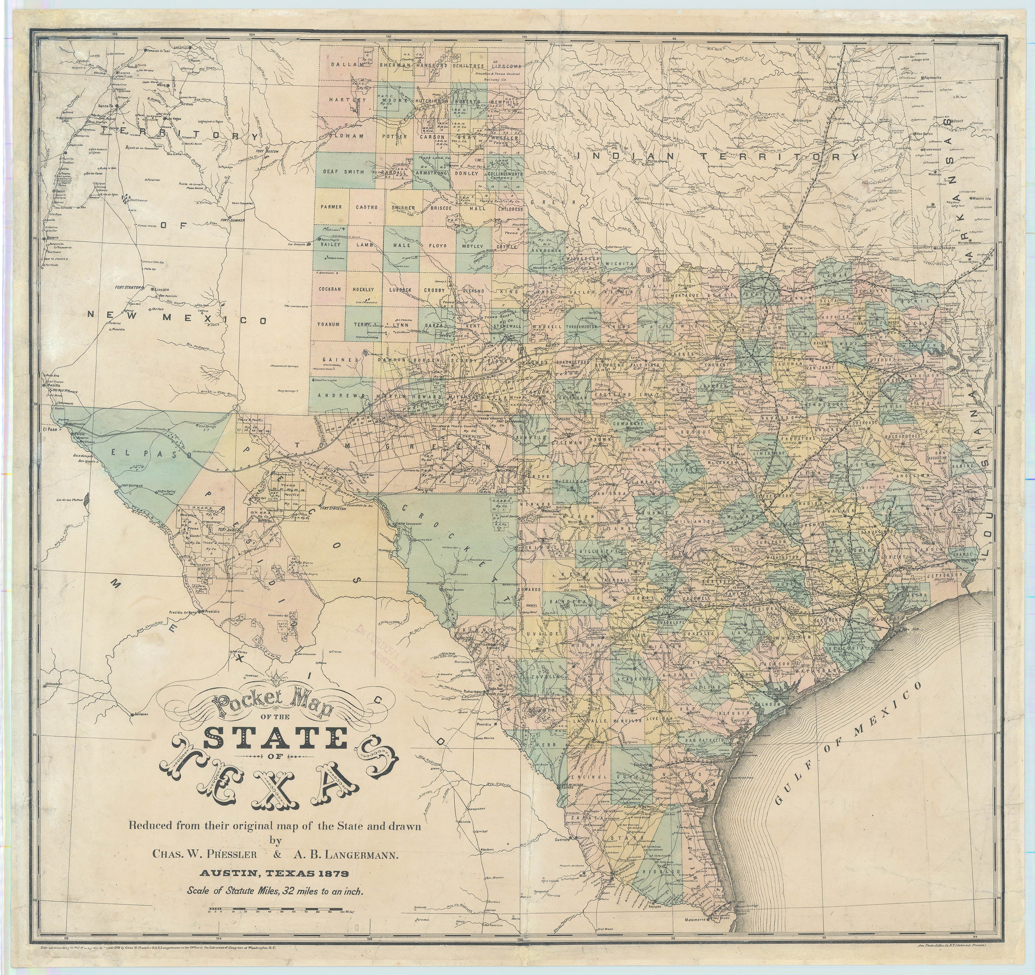
Very Rare Texas Map - Twilight of Frontier
Hand-colored lithographed map, a reduced size version of Pressler and Langermann’s map of the state produced by the General Land Office of Texas (see note below regarding that map in subsection “Rarity”). The map was compiled from records on file at the General Land Office as well as multiple other sources to which Pressler and Langermann had direct access.
The map contains detailed county information and includes portions of New Mexico, Indian Territory, Arkansas, Louisiana, and Mexico. Packed with granular detail, the map shows rivers, mountainous areas, counties, cities, towns, forts, camps, roads, numerous railroad company land grants, and Indian agencies in the Indian Territory. At yet another level of granularity, springs, wells and water holes are all well marked, critical locales for driving cattle across the Llano Estacado. Mackenzie’s road, named after the larger-than-life Ranald Mackenzie, traverses the panhandle.
Martin & Martin write, "All of Pressler's maps represented the highest standards in cartographic excellence, incorporating the most recent information from the files of the General Land Office. Along with de Cordova maps, Pressler's maps can be regarded as the first truly accurate maps of the state because of the actual surveys which had been accomplished. By the time of the 1879 publication, most of the Texas counties had reached their present size and shape, and railroads and roads had added greatly to the responsibilities of the mapmakers. Pressler...record[ed] the greatest era of change in Texas history."
Rarity
Only the third to come to market in the last 30 years, very scarce in the trade. Three is a fortuitous number for Pressler maps – the large version of this map, from which the instant example is conceived, is known in only three copies, one of which sold at auction in 2023 for an eye-watering $705,000.
Principal Authorities
Texas State Historical Association Handbook, accessed on-line, 1-11-2024. Martin & Martin, Contours of Discovery, pp. 57-58.
Background on Creator
A native of Prussia, Karl Wilhelm "Charles" Pressler (1823-1907) studied cartography and surveying in Weisensee before becoming disillusioned with the state of war and politics in Europe, joining the Adelsverein and immigrating to Texas in 1846. Almost immediately he began work for Jacob de Cordova, leading his surveying expeditions and assisting him on his well-known 1849 map of Texas. In 1850 he began work with the Texas General Land Office (GLO).
His legendary career at the GLO spanned 49 years, only interrupted by his time spent in the Confederate engineering department, during the Civil War. He became the GLO’s principal draftsman in 1858 and chief draftsman in 1865 and, except for short periods of service elsewhere, served until his retirement on January 16, 1899. Pressler published several important maps of Texas beginning in 1851 and assisted with the preparation of de Cordova's maps. In 1879 Pressler and Langermann issued a map of Texas in three sizes, including the one on offer here. He is also credited with the preparation of thirty-eight Texas county maps.
Condition
Backed with tissue with closed tears in upper left quadrant, folds reinforced with archival tape, a few minor holes at folds.