
- Author: Sebastian Munster
- Date: 1550
- Medium: Woodblock engraving
- Condition: Excellent
- Inches: 10" x 13 1/2" image size
- Centimeters: 25.5 x 34
- Product ID: 003888
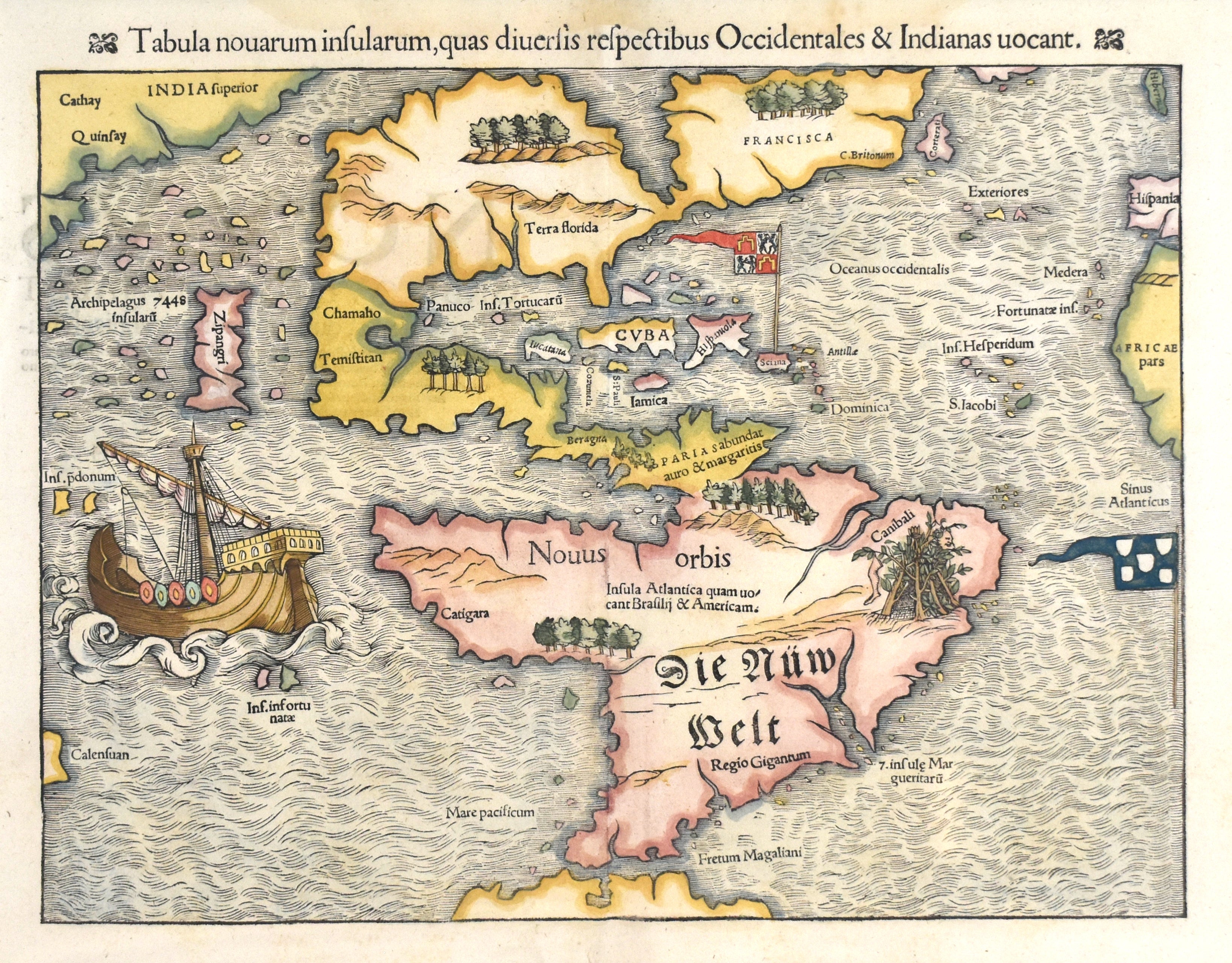
Munster's map of The New World (Die New Welt) was first published in his 1528 edition of Solinus; it subsequently appeared in the four editions of Ptolemy and virtually of the editions of Cosmographia. It was an excellent example of the woodcut process, employing the common technique of supplying the place names by means of metal types inserted into the woodblock. These names could easily be interchanged as needed for editions in different languages, and states of the map appeared in Latin, German, French, and others.
Munster presented a remarkably advanced outline of the American continents, especially considering that less than fifty years had elapsed since the first voyage of Columbus. He depicted the New World as one landmass and confirmed Waldseemuller's christening of the continents after Vespucci by appending the name "American" in South America. He clearly had firsthand reports of recent explorations at his disposal, and his delineation of North America followed closely the exemplar of Giovanni da Verrazzano after his voyage of 1524. The Italian navigator, when sailing off the coast of what is now the Outer Banks of North Carolina, mistook Pamlico Sound for the Pacific ocean, a tantalizingly short distance across a narrow neck of land. This so-called Sea of Verrazzno was shown by Munster nearly cutting North America in two, and in turn opened into a mythical strait connecting the Atlantic with the Pacific. This depiction, along with the place names "Francisca" and "Terra Florida," apportioning the continent between the French and the Spanish, appeared here on a printed map for perhaps the first time and must have contributed substantially to the wide currency of Verrazzano's ideas. Munster also knew definitely of Magellan's discoveries since he appended that explorer's name to the straits south of the mainland. Although Munster presented a good delineation of the Gulf of Mexico, he mistakenly showed Tucatan as island, and his rendering of Temistitan (Tenoxtitlan, or Mexico City) gave it an erroneous connection with the Gulf. Interior details to the north were nonexistent.
Munster interestingly combined the factual material he had at hand with the folklore and myth he must have derived in part from Solinus. The "Regio gigantum" (region of the giants) in South America, the archipelago of 7,448 islands near Japan, and the depiction of the cannibal's hut complete with dismembered leg are all examples of this influence.
Munster's map of The New World was probably the single most widely distributed map of America at the time. His rendering of a single landmass, the confirmation of the name America, and the dissemination of the misinformation of the Verrazzano combine to make it an important step in the cartographic history of the region.